Saturday, August 15, 2020
UPDATE: Eureka Sets Record, Thunderstorms Inland as Hot Temps Continue
Posted By Kimberly Wear @kimberly_wear on Sat, Aug 15, 2020 at 3:17 PM
UPDATE:
It's not quite official until midnight, but all signs point to Eureka breaking the Aug. 15 record of 73 degrees set in 2013 by hitting 78 degrees today, the Eureka office of the National Weather Service states.
It's not quite official until midnight, but all signs point to Eureka breaking the Aug. 15 record of 73 degrees set in 2013 by hitting 78 degrees today, the Eureka office of the National Weather Service states.
PREVIOUS:
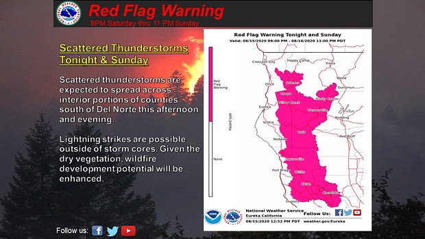
Scattered thunderstorms are expected to hit areas of inland Humboldt County this afternoon and evening, bringing the potential for new wildfires, according to the Eureka office of the National Weather Service.
Needless to say, the region’s hot streak is continuing for a second day, with a heat advisory in effect until 7 p.m. for inland areas, with maximum temperatures between 100 and 110 degrees. Some relief is expected from overnight temperatures in the upper 50s to mid 60s.
"Some minor cooling may take place Sunday, but residents can expect prolonged above average temperatures for several days," the advisory states.
On the coast, Eureka fell 1 degree short of the Aug. 14 record at 73, although the record for Aug. 15 — 73 degrees — is expected to be broken today, the service noted.
Meanwhile, the Red Salmon Complex stands at 10,895 acres with 35 percent containment, according to this morning's update.
#RedSalmonComplex
— Shasta-Trinity NF (@ShastaTrinityNF) August 15, 2020
The Red Salmon Complex is 10,895 acres and 35% contained. There are 1,490 personnel assigned to the Complex. For more incident info visit: https://t.co/Yh8aBtQpaz #SixRiversNF #KlamathNF #ShastaTrinityNF@SixRiversNF @Klamath_NF @ShastaTrinityNF pic.twitter.com/9LTf4GWxJo
Speaking of...
Readers also liked…
more from the author
-
Huffman Joins Colleagues in Calling for Biden to ‘Pass the Torch’
- Jul 19, 2024
-
SECOND UPDATE: Victim of Fatal Shooting Identified
- Jul 17, 2024
-
Eureka Man Killed in SoHum Crash
- Jul 1, 2024
- More »


