Sunday, January 30, 2022
Turns Out the Dec. 20 Earthquake was Actually Two
Posted By Kimberly Wear @kimberly_wear on Sun, Jan 30, 2022 at 11:00 PM
So, about that magnitude-6.2 earthquake on Dec. 20. Turns out it was actually overlapping temblors separated by a matter of seconds, according to the United States Geological Survey.
In a Friday news release, the USGS reports that further evaluation by its staff and others at UC Berkeley, in collaboration with experts at Cal Poly Humboldt, determined two quakes occurred that day in quick succession at different locations in the seismically active Mendocino triple junction.
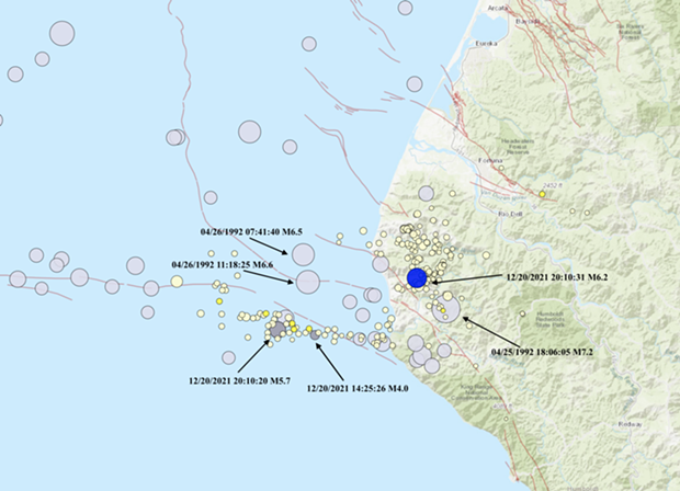
The first is now thought to be a magnitude-5.7 on the boundary of the Pacific plate and the Gorda plate, believed to be a foreshock, followed 11 seconds later by a magnitude-6.2 onshore near Petrolia on the Gorda plate.
“Because of the logarithmic nature of earthquake magnitudes, M5.7 + M6.2 = M6.24, which is why the magnitude of the initial single event didn’t change when it was split into two events,” the release states. “Seismologists are still working to disentangle the two events more precisely, and the magnitudes of the two events may adjust slightly in the future.”
Lori Dengler, a Geology professor emeritus of Humboldt State University (now Cal Poly Humboldt) who specializes in earthquake hazards, said in her weekly Times-Standard column that the area where the earthquakes took place is an “incredibly complex zone.”
“When separate earthquakes are closely spaced, it is hard to sort out where each begins and ends because the seismic traces overlap,” she wrote.” Fortunately, we now have a number of seismic stations in the triple junction area and many more have been established in Northern California as part of the earthquake early warning efforts. By carefully examining all the records, the trained eyes of seismologists were able to separate these near twins and put each in its proper place.”
Read the USGS release below:
Two overlapping earthquakes on a seismic record look like one big messy event. On December 20, 2021, after Petrolia residents felt shaking, the USGS-UC Berkeley Northern California Seismic System processed the data and announced that a magnitude 6.2 had occurred offshore on the Mendocino transform fault.
In the subsequent weeks since the event, USGS and UC Berkeley staff have carefully analyzed the data in collaboration with local experts at Humboldt State University. They have concluded that the Petrolia earthquake was really two Petrolia earthquakes 10 seconds apart in two different locations. The first event was a magnitude 5.7 offshore on or near the east-west trending Mendocino transform fault that demarks the plate boundary between the Pacific plate and southern Juan de Fuca plate (alternatively termed the Gorda plate). It was followed 11 seconds later by an M6.2 about 30 km (19 mi) to the ENE, onshore near Petrolia. Preliminary analysis suggests that the M6.2 event occurred in the Gorda plate, based on the depth and the focal mechanism. Most of its aftershocks appear to be in the Gorda plate. Seismologists are interpreting the M5.7 as a foreshock to the M6.2, but more investigation of the data is needed to confirm this hypothesis. (The M5.7 was itself preceded by a magnitude 4.0 foreshock almost 6 hours earlier).
Because of the logarithmic nature of earthquake magnitudes, M5.7 + M6.2 = M6.24, which is why the magnitude of the initial single event didn’t change when it was split into two events. Seismologists are still working to disentangle the two events more precisely, and the magnitudes of the two events may adjust slightly in the future.
Earthquakes are common in the region around the Mendocino triple junction, which is the meeting place of the Pacific, Gorda, and North American plates and marks the transition between the right-lateral strike-slip motion dominated by the San Andreas Fault System to the south and the oblique-collisional motion of the Cascadia Subduction zone to the north. In the past century, there were 40 other earthquakes of M6 or larger, including six earthquakes M7 or larger, within 250 km (155 mi) of the December 20 earthquakes. The majority of these events have occurred offshore, within the Juan de Fuca/Gorda plate or along the Mendocino transform fault.
The December 20, 2021, M6.2 occurred approximately 8 km (5 mi) NW of the April 25, 1992, M7.2 earthquake, which caused significant shaking across northern California, multiple landslides, a rockfall and a tsunami reaching 1.1 meters at Crescent City, California. The 1992 event, which is generally considered to have occurred on a shallow thrust fault in the North American plate, was followed by two large aftershocks of M6.5 and M6.6 offshore in the Gorda plate – an earlier example of the complex interaction of seismicity from one plate to another in this area.
Speaking of...
Readers also liked…
more from the author
-
Huffman Joins Colleagues in Calling for Biden to ‘Pass the Torch’
- Jul 19, 2024
-
SECOND UPDATE: Victim of Fatal Shooting Identified
- Jul 17, 2024
-
Eureka Man Killed in SoHum Crash
- Jul 1, 2024
- More »
