Friday, September 11, 2020
New Evacuation Mapping Tool for Hopkins Fire
Posted By Iridian Casarez on Fri, Sep 11, 2020 at 12:45 PM
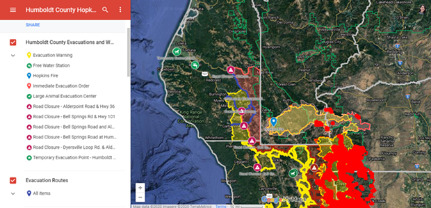
The Humboldt County Sheriff's Office of Emergency Services has created an interactive map of Humboldt County in relation to the Hopkins Fire.
The interactive map includes road closures, evacuation orders, large animal evacuation centers, temporary evacuation sites and the location of the Hopkins Fire.
See the full interactive map below.
The interactive map includes road closures, evacuation orders, large animal evacuation centers, temporary evacuation sites and the location of the Hopkins Fire.
See the full interactive map below.
Speaking of...
-

Huffman, Citing Rio Dell, Asks FEMA for more ‘Flexible, Equitable’ Access to Disaster Aid
Sep 25, 2023 -

CA Officials Respond to Tropical Storm Hilary, Ojai quake and Wildfires with the Possibility of More Lightning in the Forecast
Aug 21, 2023 -

Four Things California Can Do as Home Insurers Retreat
Jun 20, 2023 - More »
Readers also liked…
more from the author
-
An Upstream Intervention
Open Door hopes state grant will help address impacts of childhood trauma
- Feb 9, 2023
-
Humboldt County Still Working to Implement Organic Waste System
- Feb 2, 2023
-
Earl Robert Bootier: 1945-2022
- Jan 25, 2023
- More »


