Tuesday, September 7, 2021
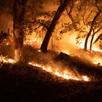
Knob Fire Holding as River Complex Grows
Posted By Kimberly Wear @kimberly_wear on Tue, Sep 7, 2021 at 11:36 AM
Fire crews continued to make progress on the Knob Fire over the holiday weekend, as crews on the McCash Fire work to protect homes near Hyapom and stop the fire's advance toward Hayfork Creek and Hyampom Road and firefighters work to protect property threatened by the River Complex, which is expected to see another round of growth today.
While coastal Humboldt County will see pretty good to moderate air quality today, conditions around Hoopa, Orleans and Willow Creek will reach "unhealthy" levels.
With fires raging across the region and resources already stretched very thin, the U.S. Forest Service has temporarily closed nine National Forests, including Klamath, Mendocino, Shasta-Trinity and Six Rivers.
Here's a brief look at each of the first burning near Humboldt and what you need to know.
The Fires
The Knob Fire, 2,414 acres, 89 percent contained
The Knob Fire burning near Willow Creek started Aug. 29 around 3 p.m. on Brush Mountain and resources from the Monument and McCash fires were sent to aid with firefighting efforts.
Crews held the Knob Fire to under 2,500 acres while increasing containment to 89 percent as of this morning.
An evacuation order remains in effect for areas east of Brushy Mountain Lookout Road/FS Road 6N08A to State Route 299, south of Victor Creek to China Creek; areas east of Brushy Mountain Lookout Road/FS Road 6N08A to the eastern perimeter of the Knob Fire south of China Creek to Friday Ridge Road; and areas east of Brushy Mountain Lookout Road/FS Road 6N08A to South Fork Trinity River, south of Friday Ridge Road to the end of the FS Road 6N20. Evacuation warnings remain in surrounding areas. For the latest map of evacuation zones, visit tinyurl.com/humcoevacmap.
The Monument Fire, 185,505 acres, 41 percent contained
Located a half mile west of Big Bar along State Route 299 east of Willow Creek, the Monument Fire was sparked by lightning on July 30.
State Route 299 has reopened but only during the day and with pilot cars leading traffic in both directions from Burnt Ranch to Helena at designated times every hour and a half starting at 7 a.m. until 7 p.m. The road will be closed from 7 a.m. to 7 p.m. for everyone except local residents with proof of address and emergency traffic.
Evacuation orders, as of yesterday evening, include all areas along Hyampom Road from Lucky Jeep Trail, east along both sides of Hyampom Road to Drink Water Gulch, including Fox Lane, Drink Water Gulch, and Phares Lane, according to the Trinity County Sheriff's Office. Warning areas include Hyampom Road east of Drink Water Gulch to Digger Gulch and South to Tule Creek Road and Green Gate Road are now under an Evacuation Warning. This includes: Turkey Track Road, Doctor Lane, Digger Gulch, Shangri La Lane, Green Gate Road, McAlexander Road.
For information on evacuation orders and warnings, evacutation sites and animal shelters, visit the Trinity County Sheriff's Office Facebook page here.
For more information, check the incident website here and a map of the fire's footprint here.
The McFarland Fire, 122,653 acres and is 98 percent contained
Sparked by lightning July 29 on McFarland Ridge south of State Route 36, the fire is burning in timberlands with fuels with historically low moisture levels in an area that hasn't burned in more than 50 years. The last update had the fire at 98 percent containment, with a full containment estimate of Sept. 9.
Find the latest information here.
River Complex 2021, 135,698 acres, 19 percent contained
Located in the Salmon/Scott River Ranger District of the Klamath National Forest, the complex consists of multiple lightning fires sparked in dry timber and brush on July 30. The full complex stretches more than 135,000 acres and originally included 31 fires, three of which remain: the Cronan, Summer and Haypress fires.
Crews lost ground on the blaze, which grew by more than 14,000 acres overnight and went from 21 percent containment on Monday to 19 percent containment, according to this morning's update.
"Fire behavior was active yesterday and will be active again today with increased growth expected. Crews will use all available tools and tactics to protect lives, property, and other values, while providing for firefighter and public safety," the update states. "The Summer Fire has merged with the Haypress Fire. On the Haypress Fire, crews are dealing with spotting in the northeast, near Blue Jay Ridge. A point of Parker’s Spot has burned into the main fire. The Coffee Spike Camp will be moved to Trinity Center today. The Cronan Fire remains in patrol status."
New evacuation orders were issued for Callahan, Mosquito Lake, and Eagle Creek.
Siskiyou County has issued evacuation orders and warnings for the communities of Ceciville, Summerville, Petersburg and Sawyers Bar while Trinity County has issued evacuation orders and warnings for the communities of Coffee Creek, Carrville, and Trinity Center. For specific information regarding evacuations please visit https://www.co.siskiyou.ca.us/emergencyservices or https:///www.trinitycounty.org/OES.
Find more information here and a map of the fires' footprints here.
The McCash Fire: 57,038 acres, 15 percent containment
Sparked by lightning on July 31, the McCash Fire is burning near Somes Bar in the Marble Mountain Wilderness in Siskiyou County in an area of timber growth with an understory of tall grass and brush was held to just more than 57,000 acres overnight and notched up a tad to 15 percent containment.
Evacuation orders and warnings are in place for areas of Siskiyou County. Visit the county's website for up-to-date information here.
The fire threatens significant cultural sites for the Karuk Tribe, as well as some structures on private lands. The current estimated containment date is Oct. 31. Find more information here.
Travel
State Route 299: Reopened during the day with pilot cars leading traffic in both directions from Burnt Ranch to Helena at designated times every hour and a half from 7 a.m. to 7 p.m. The road will be closed from 7 p.m. to 7 a.m. to everyone except local residents with proof of address.
State Route 36: Open.
For the most up to date road information, visit CalTrans' road information site here.
Air Quality
Wildfire smoke has triggered an air quality advisory — with "very unhealthy" conditions — in areas of Trinity County and eastern Humboldt County, including Orleans and Hooopa, according to the North Coast Unified Air Quality Management District.
For the latest air quality information, click here.
Here's the district's full rundown:
"Moderate" — Sensitive individuals should limit prolonged or heavy exertion "Unhealthy for Sensitive Groups" — Sensitive groups should reduce prolonged or heavy outdoor exertion
"Unhealthy" — Sensitive groups should avoid all prolonged or heavy outdoor exertion
"Very Unhealthy" — Everyone should avoid prolonged or heavy exertion
"Hazardous" — Everyone should avoid any outdoor activity
For the latest air quality information, click here and here.
While coastal Humboldt County will see pretty good to moderate air quality today, conditions around Hoopa, Orleans and Willow Creek will reach "unhealthy" levels.
With fires raging across the region and resources already stretched very thin, the U.S. Forest Service has temporarily closed nine National Forests, including Klamath, Mendocino, Shasta-Trinity and Six Rivers.
Here's a brief look at each of the first burning near Humboldt and what you need to know.
The Fires
The Knob Fire, 2,414 acres, 89 percent contained
The Knob Fire burning near Willow Creek started Aug. 29 around 3 p.m. on Brush Mountain and resources from the Monument and McCash fires were sent to aid with firefighting efforts.
Crews held the Knob Fire to under 2,500 acres while increasing containment to 89 percent as of this morning.
"Last night, fire behavior was minimal, with no spotting outside of the fire perimeter," this morning's update states. "Today, crews will continue to work on the north side strengthening and improving containment lines and extinguishing any hotspots within 300 feet of the perimeter of the fire."
An evacuation order remains in effect for areas east of Brushy Mountain Lookout Road/FS Road 6N08A to State Route 299, south of Victor Creek to China Creek; areas east of Brushy Mountain Lookout Road/FS Road 6N08A to the eastern perimeter of the Knob Fire south of China Creek to Friday Ridge Road; and areas east of Brushy Mountain Lookout Road/FS Road 6N08A to South Fork Trinity River, south of Friday Ridge Road to the end of the FS Road 6N20. Evacuation warnings remain in surrounding areas. For the latest map of evacuation zones, visit tinyurl.com/humcoevacmap.
The Monument Fire, 185,505 acres, 41 percent contained
Located a half mile west of Big Bar along State Route 299 east of Willow Creek, the Monument Fire was sparked by lightning on July 30.
State Route 299 has reopened but only during the day and with pilot cars leading traffic in both directions from Burnt Ranch to Helena at designated times every hour and a half starting at 7 a.m. until 7 p.m. The road will be closed from 7 a.m. to 7 p.m. for everyone except local residents with proof of address and emergency traffic.
"Two areas of the fire remain active: the north side, which is primarily in the Trinity Alps Wilderness Area, and the southwest side, which is east of Hyampom," a Sept. 6 update states. "While suppression efforts are being implemented to protect the Trinity Alps Wilderness Area, the Trinity Wild and Scenic River, Inventoried Roadless areas, and endangered species habitat, the highest priority remains the southwest side. Numerous resources are positioned near Hyampom to protect structures and make every effort to halt the fire’s southward advance toward Hayfork Creek and Hyampom Road."
Evacuation orders, as of yesterday evening, include all areas along Hyampom Road from Lucky Jeep Trail, east along both sides of Hyampom Road to Drink Water Gulch, including Fox Lane, Drink Water Gulch, and Phares Lane, according to the Trinity County Sheriff's Office. Warning areas include Hyampom Road east of Drink Water Gulch to Digger Gulch and South to Tule Creek Road and Green Gate Road are now under an Evacuation Warning. This includes: Turkey Track Road, Doctor Lane, Digger Gulch, Shangri La Lane, Green Gate Road, McAlexander Road.
For information on evacuation orders and warnings, evacutation sites and animal shelters, visit the Trinity County Sheriff's Office Facebook page here.
For more information, check the incident website here and a map of the fire's footprint here.
The McFarland Fire, 122,653 acres and is 98 percent contained
Sparked by lightning July 29 on McFarland Ridge south of State Route 36, the fire is burning in timberlands with fuels with historically low moisture levels in an area that hasn't burned in more than 50 years. The last update had the fire at 98 percent containment, with a full containment estimate of Sept. 9.
Find the latest information here.
River Complex 2021, 135,698 acres, 19 percent contained
Located in the Salmon/Scott River Ranger District of the Klamath National Forest, the complex consists of multiple lightning fires sparked in dry timber and brush on July 30. The full complex stretches more than 135,000 acres and originally included 31 fires, three of which remain: the Cronan, Summer and Haypress fires.
Crews lost ground on the blaze, which grew by more than 14,000 acres overnight and went from 21 percent containment on Monday to 19 percent containment, according to this morning's update.
"Fire behavior was active yesterday and will be active again today with increased growth expected. Crews will use all available tools and tactics to protect lives, property, and other values, while providing for firefighter and public safety," the update states. "The Summer Fire has merged with the Haypress Fire. On the Haypress Fire, crews are dealing with spotting in the northeast, near Blue Jay Ridge. A point of Parker’s Spot has burned into the main fire. The Coffee Spike Camp will be moved to Trinity Center today. The Cronan Fire remains in patrol status."
New evacuation orders were issued for Callahan, Mosquito Lake, and Eagle Creek.
Siskiyou County has issued evacuation orders and warnings for the communities of Ceciville, Summerville, Petersburg and Sawyers Bar while Trinity County has issued evacuation orders and warnings for the communities of Coffee Creek, Carrville, and Trinity Center. For specific information regarding evacuations please visit https://www.co.siskiyou.ca.us/emergencyservices or https:///www.trinitycounty.org/OES.
Find more information here and a map of the fires' footprints here.
The McCash Fire: 57,038 acres, 15 percent containment
Sparked by lightning on July 31, the McCash Fire is burning near Somes Bar in the Marble Mountain Wilderness in Siskiyou County in an area of timber growth with an understory of tall grass and brush was held to just more than 57,000 acres overnight and notched up a tad to 15 percent containment.
"Firefighters are preparing for changing weather and future wind events," an update states. "Today, a southerly flow will bring increased winds from the southwest that have the potential to push the fire northward."
Evacuation orders and warnings are in place for areas of Siskiyou County. Visit the county's website for up-to-date information here.
The fire threatens significant cultural sites for the Karuk Tribe, as well as some structures on private lands. The current estimated containment date is Oct. 31. Find more information here.
Travel
State Route 299: Reopened during the day with pilot cars leading traffic in both directions from Burnt Ranch to Helena at designated times every hour and a half from 7 a.m. to 7 p.m. The road will be closed from 7 p.m. to 7 a.m. to everyone except local residents with proof of address.
State Route 36: Open.
For the most up to date road information, visit CalTrans' road information site here.
Air Quality
Wildfire smoke has triggered an air quality advisory — with "very unhealthy" conditions — in areas of Trinity County and eastern Humboldt County, including Orleans and Hooopa, according to the North Coast Unified Air Quality Management District.
For the latest air quality information, click here.
Here's the district's full rundown:
Orleans – Overall Unhealthy; Hazardous this morning; potential for Good to Moderate tonight
Hoopa – Unhealthy in the morning; potential for improvement in evening
Willow Creek – Overall Unhealthy
Hoopa – Unhealthy in the morning; potential for improvement in evening
Willow Creek – Overall Unhealthy
Trinity Center/Coffee Creek – Unhealthy in morning, Good/Moderate today; Hazardous periods overnight
Douglas City – Overall Unhealthy
Hayfork – Overall Unhealthy
Douglas City – Overall Unhealthy
Hayfork – Overall Unhealthy
Eureka (including Scotia to Trinidad) – Good to Moderate
Garberville & Redway – Good to Moderate, afternoon improvement
Weitchpec – Overall USG; Very Unhealthy in the morning then potential for Good to Moderate tonight
Garberville & Redway – Good to Moderate, afternoon improvement
Weitchpec – Overall USG; Very Unhealthy in the morning then potential for Good to Moderate tonight
"Moderate" — Sensitive individuals should limit prolonged or heavy exertion "Unhealthy for Sensitive Groups" — Sensitive groups should reduce prolonged or heavy outdoor exertion
"Unhealthy" — Sensitive groups should avoid all prolonged or heavy outdoor exertion
"Very Unhealthy" — Everyone should avoid prolonged or heavy exertion
"Hazardous" — Everyone should avoid any outdoor activity
For the latest air quality information, click here and here.
Speaking of...

Readers also liked…
About The Author
Kimberly Wear
Bio:
Kimberly Wear is the assistant editor of the North Coast Journal.
Kimberly Wear is the assistant editor of the North Coast Journal.
more from the author
-
Dust to Dust
The green burial movement looks to set down roots in Humboldt County
- Apr 11, 2024
-
Our Last Best Chance
- Apr 11, 2024
-
Judge Rules Arcata Can't Put Earth Flag on Top
- Apr 5, 2024
- More »


