Thursday, October 15, 2020
High Winds and Low Humidity May Increase Fire Activity
Posted By Iridian Casarez on Thu, Oct 15, 2020 at 1:51 PM
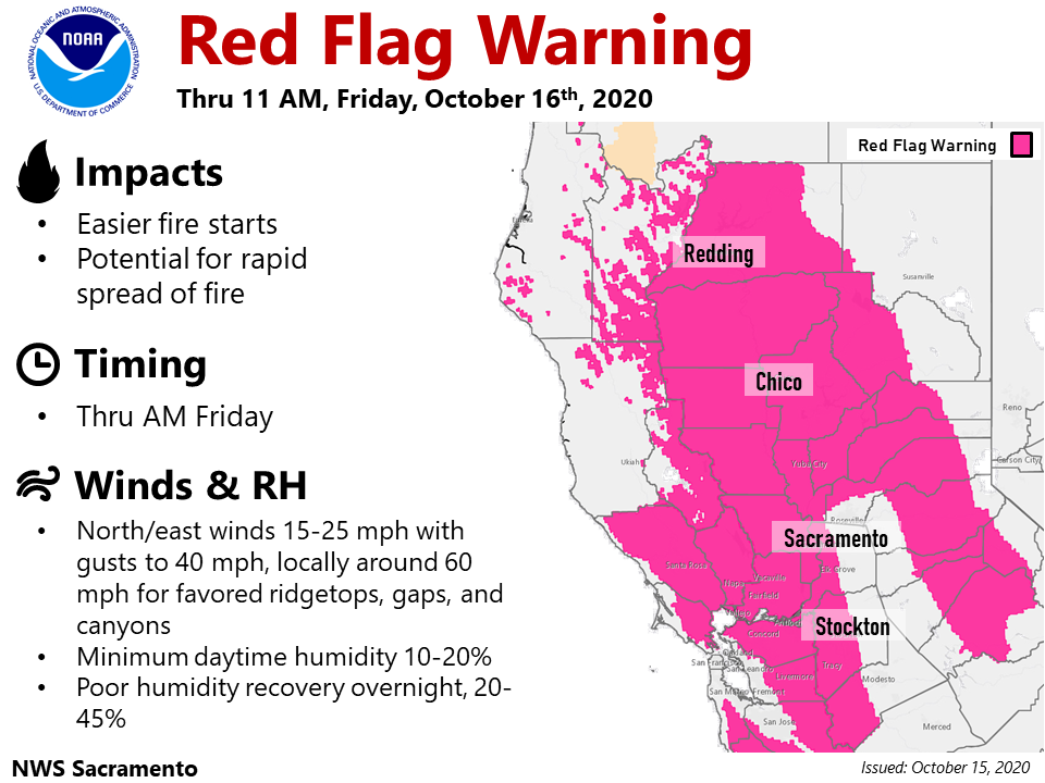
High winds with gusts of up to 40 mph and low levels of humidity are expected through Friday in most of the regions.
PG&E initiated a Public Safety Power Shutoff yesterday due to the Red Flag Warning. The PSPS will affect some Humboldt County homes including an estimated 187 Humboldt customers in the Bridgeville, Blocksburg and Alderpoint areas around 4 p.m. today lasting through 10 p.m. Friday.
Read the full fire update press releases below.
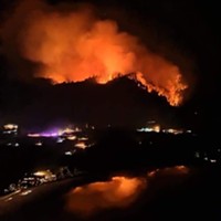
The Red Salmon Complex
The August Complex
The Slater-Devil Fire
Slater and Devil Fires Update
Thursday, October 15, 2020; 9:00 a.m.
Fire managers are asking for help from the public in observing the various area and road closures in effect for public and firefighter safety.
Slater Fire - 156,610 acres and 80% containment
Crews remain vigilant in patrolling and monitoring along the fire’s northern, southern, and southwest flanks, with very few areas of heat being found inside containment lines. Several areas of smoke from burning that is contained within the interior of the fire east of Takilma were visible yesterday. Aerial and foot patrols were dispatched and determined that there were no threats to containment. Smoke may continue to be visible today from inside containment lines. On the northeast flank of the fire, crews remain focused on strengthening containment lines south of Swan Peak.
Crews continue to coordinate operations with the local power company to remove fire-damaged trees along Grayback Road. Two divisions are assigned to this effort, one working from Happy Camp to the north and one working from Oregon to the south. They are each accomplishing about 3/10 of a mile per day. The restoration of power to Happy Camp residents remains a priority.
In the Knopki and Chicago Creek drainages, crews are utilizing helicopters for water bucket drops on areas of persistent heat. Crews are also continuing to secure fire lines in this area, focused on strengthening containment lines south of Sanger Peak. Connecting those lines to the 2018 Natchez Fire footprint is a precaution against further fire spread to the west.
Aviation assets remain available for aerial reconnaissance and other operations as needed.
Devil Fire - 8,885 acres and 60% containment
The Devil Fire is in patrol status using aviation and ground resources.
Weather and Fire Behavior
Red flag weather is developing today through Friday for the California portion of the fire east of Kelly Lake and Twin Valley Creek, with warm temperatures and lower humidity. Throughout the fire area, north-northeast winds will bring drier air from the east, with increased winds on ridge tops and breezy conditions elsewhere. Recently moistened fuels within the fire area will continue to dry out with increasing potential for creeping fire activity.
Evacuations
The mandatory evacuation order in Siskiyou County was lifted and repopulation is in effect for the residents and roadways off of Indian Meadows Road. For specific information regarding evacuations see the following:
Siskiyou County Office of Emergency Services information:
(530) 643-3662 or www.facebook.com/SiskiyouCountyOES
Del Norte County information: (707) 464-7213 or www.facebook.com/DelNorteOfficeOfEmergencyServices and www.preparedelnorte.com/
Closures and Restrictions
The Klamath, Six Rivers, and Rogue River-Siskiyou National Forests have issued fire area closure orders for the Slater and Devil Fires. The Pacific Southwest Region is under emergency fire restrictions, although the use of gas stoves is allowed in open developed recreation sites. Find closure orders and maps at: www.fs.usda.gov/klamath, www.fs.usda.gov/rogue-siskiyou, and www.fs.usda.gov/srnf.
Portions of both the Rogue River-Siskiyou National Forest’s Wild Rivers Ranger District and Siskiyou Mountains Ranger District have reopened for use. Some areas remain closed for emergency crews’ safety and to allow for fire suppression and burned area recovery. Find closure orders and maps at: www.fs.usda.gov/alerts/rogue-siskiyou/alerts-notices. The latest updates on fire danger levels and public use restrictions within the Forest are available at https://www.fs.usda.gov/detail/rogue-siskiyou/news-events/?cid=FSEPRD824854.
The Bureau of Land Management Medford District has public lands closures in effect near the Slater Fire and South Obenchain Fire. Find closure area maps at: www.blm.gov/programs/public-safety-and-fire/fire-and-aviation/regional-info/oregon-washington/fire-restrictions.
Burned Area Emergency Recovery information and resources for private landowners impacted by the Slater and Devil Fires are available at: inciweb.nwcg.gov/incident/7237/.
Speaking of...
-
Huffman, Citing Rio Dell, Asks FEMA for more ‘Flexible, Equitable’ Access to Disaster Aid
Sep 25, 2023 -
CA Officials Respond to Tropical Storm Hilary, Ojai quake and Wildfires with the Possibility of More Lightning in the Forecast
Aug 21, 2023 -
Four Things California Can Do as Home Insurers Retreat
Jun 20, 2023 - More »
Readers also liked…
About The Author
Iridian Casarez
Iridian Casarez was a staff writer at the North Coast Journal from 2019-2023.
more from the author
-
An Upstream Intervention
Open Door hopes state grant will help address impacts of childhood trauma
- Feb 9, 2023
-
Humboldt County Still Working to Implement Organic Waste System
- Feb 2, 2023
-
Earl Robert Bootier: 1945-2022
- Jan 25, 2023
- More »


