'Ground Zero:' Coastal Commission Approves Safety Corridor Project, Worries Sea Level Rise May Leave it Under Water
By Elaine Weinreb
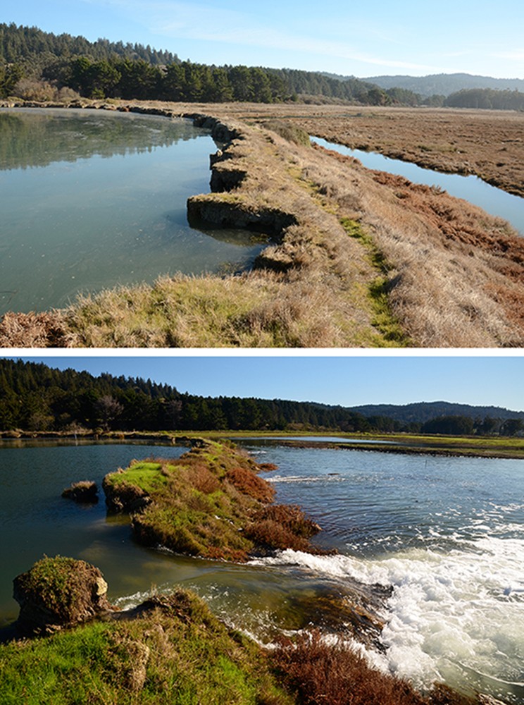
Looking over Humboldt Bay at the U.S. Highway 101 safety corridor.
[

      {
        "name": "Top Stories Video Pair",
        "insertPoint": "7",
        "component": "17087298",
        "parentWrapperClass": "fdn-ads-inline-content-block",
        "requiredCountToDisplay": "1"
      }

    ]
While Caltrans' project on the 6-mile stretch of U.S. Highway 101 that connects Eureka and Arcata is aimed at improving safety for motorists, the agency got an earful Aug. 7 from California Coastal Commissioners who felt it is ignoring a potentially far more dangerous threat: sea level rise.
"This is ground zero," said Chair Dayna Bochco. "We don't have a lot of time right here. The traffic is a terrible problem. The water is going to be a worse one."
The meeting — which saw commissioners ultimately approve a coastal development permit for the long-awaited safety corridor project — featured some dire warnings of the imminent threat of sea level rise to the low-lying areas of coastal Humboldt County, including the stretch of 101, which one commissioner said has been identified as the "most vulnerable" in the state. The discussion of sea level rise at the meeting was so foreboding, in fact, that one of the state's highest ranking planning officials walked away saying California needs to urgently come up with a multi-agency plan — and a lot of funding — to begin charting a course forward.
Anyone who frequently drives "the safety corridor" has probably experienced a few heart-stopping incidents at the Indianola cutoff, in which frantic drivers make left turns against two or three lanes of 65-mph traffic. Although the legal speed limit on the corridor is 50 mph, few drivers observe it.
During rush hour, the number of cars waiting to turn often overflows from the short turn lane, resulting in a line of vehicles standing still in the southbound fast lane. Not surprisingly, the accident rate at this location is 200 percent higher than statewide averages.
In addition to the Indianola cutoff, the corridor hosts five other potentially life-threatening at-grade intersections, including those at the Bayside cutoff and Airport Road.
When implemented in May of 2002 on the heels of a string of deadly crashes that helped earn the stretch of roadway the nickname "Blood Alley," the "safety corridor" was always intended to be a temporary fix. According to Caltrans, such safety zones just don't work long-term, as over time motorists began ignoring the speed limit and the flashing signs and, gradually, start accelerating.
Caltrans has been working on a permanent fix for this mess for more than a decade, but efforts have quietly ramped up in recent years and got a major boost when the Humboldt County Association of Governments allocated the agency $31 million for the improvement project. But because this section of 101 sits within the Coastal Zone, the transportation agency had to get the blessing of the California Coastal Commission before it could move forward. The project was the subject of a four-hour meeting of the commission Aug. 7 in Eureka.
Coastal Commission analyst Peter Allen began by walking the overflow crowd at the Wharfinger Building through the past, present and future of the corridor.
Caltrans intends to close all six T-intersections, where two way streets meet the freeway. In their place, the agency will construct an overpass at the Indianola cutoff, as well as a second intersection that will be partially controlled by traffic lights at Airport Road. Other than at the Airport Road signal, there will be no left turns across the median in either direction, eliminating the threat posed by cross traffic, although some right turns off and on the freeway will still be permitted.
If commissioners' had any lingering doubts about the necessity of an overpass at Indianola, they seemed to vanish when a member of the public showed several scary videos of near misses at the cutoff.
The intersection at Airport Road provides the sole access point to the Murray Field Airport, a residential trailer park and the commercial center along Jacobs Avenue. Because the freeway offers the only means for businesses and residents to get to and from Eureka, Caltrans cannot simply block off the intersection. Instead, it will install lights that will stop northbound traffic as southbound traffic from Airport Road enters the freeway safely.
Caltrans also intends to lengthen the acceleration and deceleration lanes from major intersections along the freeway, eliminating, for example, the pedal-to-the-metal maneuver currently needed to get on the freeway from Mid-City Motor World. The agency also plans to repair some bridges, culverts, tide gates and railings.
This particular project does not involve the removal of any eucalyptus trees, according to Allen. However, some smaller trees and shrubs will be removed to make room for the improved acceleration and deceleration lanes, with new trees planted in other areas to make up for the removals.
Because the corridor is directly adjacent to the bay, any improvements will involve filling or impacting wetlands, which is frowned upon by state law. As a mitigation for destroying 10 acres of wetlands, the transportation agency will restore 179 acres of salt marsh habitat on Tulawat Island (also known as Indian Island) in Humboldt Bay. Spartina, an invasive grass that chokes out all native habitat, will be removed from the island and monitored for years to make sure it does not return.
Work on the roadway improvements is scheduled to begin next year and be completed by 2026. Caltrans expects to keep the freeway open and fully functioning throughout construction, except for two brief night-time closures when southbound traffic will be re-routed on Samoa Boulevard.
Vigorous public discussion followed Allen's presentation. Some people were unhappy that not all the billboards along the corridor will be removed. (Caltrans says it has removed all it legally can.) Others did not think the Spartina removal was an adequate mitigation for the loss of wetlands. Some wondered why the speed limit couldn't be lowered further, or a stoplight placed at the Indianola cutoff rather than the full interchange. And some were afraid that Old Arcata Road would see an additional traffic burden.
The real fly in the ointment, however, as far as the commissioners were concerned, is the inevitable rise of the ocean. The freeway is right next to the bay, and the land that is now underneath it was salt marsh less than 150 years ago. Dikes and drainage made it possible to build a railroad and a highway, and to create new pastureland along the bay — at least for a while. But several commissioners wondered if it makes sense to pour millions of dollars into a road that may be under water in the not too distant future.
The Coastal Commission staff report noted that "the proposed development is susceptible to flood risks and extremely vulnerable to the impacts of Sea Level Rise. The flood risks to the highway corridor are from both the bay side to the west and the inland eastern side. ... breaching of the unmaintained dikes is a significant and growing problem [and] flooding issues will worsen with Sea Level Rise.
"The bridge and the interchange have an expected lifespan of approximately 80 years, or to approximately the year 2100," the report continues. "Significant segments of the corridor will be regularly inundated by 1.5 feet of Sea Level Rise, which is currently projected to impact the area potentially as early as the 2030-to-2040 period and likely by the 2040-to-2050 time frame. Regular storm events will flood segments of the corridor with minimal Sea Level Rise. ... Moreover, other project components ... are not being adapted to Sea Level Rise in this project."
To deal with these issues, Coastal Commission staff had asked Caltrans to submit an as-yet unspecified "adaptation plan" either by 2030 or "no later than one year after flooding closes any travel portion of the Highway Corridor four times within any 12-month period."
Several of the commissioners found this reasoning baffling. Commissioner Carole Groom wanted to know why Caltrans didn't simply place the whole highway on a causeway. Caltrans Project Manager Jeff Pimentel replied that a causeway would be a sea level rise project, whereas this was a "safety project." Commissioner Caryl Hart thought it strange that sea level rise planning would not even begin until after the roadway had already flooded four times.
"It's hard to hear you say that you can't plan because you don't know what the sea level rise is going to be," she told Pimentel.
"Waiting for the flooding," mused Commissioner Donne Brownsey. "First of all, I think things are going to happen way faster. I don't think you should wait for flooding. I think you should set that deadline for 2025. ... We're seeing this as an opportunity to be a model, not a story about another catastrophe."
"We've identified this particular stretch of highway as the most vulnerable on the California coast," said Vice Chair Steve Padilla, describing Caltrans' plan as "wholly insufficient."
Commissioner Mike Wilson, Humboldt County's Third District supervisor who was attending his first commission meeting since being recently appointed by Gov. Gavin Newsom, said, "The time frame as set forth here will put us behind the ball, not ahead of the ball." He noted that when statewide disasters strike, as a rural community, Humboldt gets left behind.
"I am quite concerned about making the timeline so long," agreed Commissioner Linda Escalante. "I have never driven on a freeway that is so at risk and so close to the waterline."
"I can't support this project," said Commissioner Sara Aminzadeh. "We're dealing with one public safety issue and we're failing to address a much larger public safety issue."
One of the public commentators was environmental planner Aldaron Laird, owner of Trinity Associates, an Arcata firm. Laird gave a wake-up call to the Humboldt Bay area in 2010 when he studied the region's vulnerability to rising seas. Much of the low-lying area around the bay — including parts of Eureka, Arcata and three smaller communities — was built on reclaimed salt marsh, diked off from the bay. The land was subsequently covered with residential, business and industrial facilities, including two sewage treatment plants and a former nuclear power plant. Now as the ocean is rising, these lands — and the highway that connects them — are in peril.
Laird addressed the Coastal Commission twice in its three days of meetings in Eureka: once while commissioners were discussing the planned improvements to 101 on Aug. 7 and again in more detail the next morning. He explained the dynamic relationship of the ocean to the land and how high tides periodically get amplified by the moon and the sun into giant king tides 8.8 feet high.
In the winter, the concurrence of a large storm surge with a king tide can result in even higher water levels, overtopping dikes and causing localized flooding. This happened in 2005, resulting in the governor declaring a state of emergency.
"When king tides reach 10 feet, a tipping point is reached, where dikes are overtopped and surrounding areas flooded." Laird said. "We are not talking about the end of the century. We're talking about today."
To make things worse, rising sea water pushes shore-side groundwater upward so that even areas untouched by the ocean may be inundated from below.
No public agency is responsible for maintaining the dikes that separate the bay from the land, Laird said, and if even one dike springs a leak, it will affect all the neighboring lands, like a hole in the wall of a bathtub.
Humboldt County Planning Director John Ford pointed out that the three most vulnerable communities — Fairhaven, King Salmon and Samoa — were also the locations of much of the county's supply of affordable housing, bringing a social justice issue into play. He added that 1 meter of sea level rise could cause $200 million per year in damage to the county's economy.
A study released earlier this summer by the Center for Climate Integrity projected that Humboldt County will have to build 142 miles of seawall — at a cost of $2.5 billion — by 2040 to protect coastal communities from sea level rise or risk abandoning them to be taken over by the encroaching sea.
At the meeting in Eureka, Commissioner Donne Brownsey wanted to know how the political leadership of the area had received Laird's information.
"With shock," replied Laird, adding that it had taken several years for the information to sink in but that county officials were now beginning to understand the immensity of the problem.
"The future of Humboldt Bay as a seaport is being threatened," he added. "As a rural part of California, we're going to need state and federal assistance because we can't do this on our own."
"If you were in a position to direct the city and the county efforts to address sea level rise, what would be your first actions, given the nearness of the impacts?" queried Brownsey.
Laird said that he would have the cities and the county and the Coastal Commission form a joint powers authority in order to move together as a region to try to find funding for adaptation.
After four hours of discussion and argument, the commission finally approved a modified version of the Caltrans project. The "adaptation plan" is to be ready by 2025 instead of 2030. Caltrans is to report out on high water levels annually instead of biennially. And to avoid a "bathtub" problem, the agency can't use dikes or armoring as the primary defense against sea level rise.
Coastal Commission Executive Director Jack Ainsworth summed up the discussion with a tone of urgency.
"We need to stress to the powers that be in Sacramento that this is no longer a slow-moving emergency," Ainsworth said. "This is ground zero. We need something like a Marshall Plan. We need to get money for planning, for design and engineering projects. And that's going to take a huge amount of resources."
Editor's note: This story was updated from a previous version to correct the spelling of Donne Brownsey's name. The Journal regrets the error.
Elaine Weinreb is a freelance journalist. She tries to re-pay the state of California for giving her a degree in environmental studies and planning (Sonoma State University) at a time when tuition was still affordable.
Speaking of...
-
Caltrans Selects Tunnel Option for Last Chance Grade
Jun 18, 2024 -

One Killed, Another Injured in 101 Crash
Apr 2, 2024 -

CHP: Three Killed in Crash on 101 North of Rio Dell
Jan 22, 2024 - More »
Comments (2)
Showing 1-2 of 2
more from the author
-
Trouble on the Mountain
A popular outdoor recreation area is also a makeshift shooting range, causing growing safety concerns
- Jan 11, 2024
- More »
Latest in News


Readers also liked…
-
Through Mark Larson's Lens
A local photographer's favorite images of 2022 in Humboldt
- Jan 5, 2023
-
'To Celebrate Our Sovereignty'
Yurok Tribe to host gathering honoring 'ultimate river warrior' on the anniversary of the U.S. Supreme Court ruling that changed everything
- Jun 8, 2023


