[

      {
        "name": "Top Stories Video Pair",
        "insertPoint": "7",
        "component": "17087298",
        "parentWrapperClass": "fdn-ads-inline-content-block",
        "requiredCountToDisplay": "1"
      }

    ]
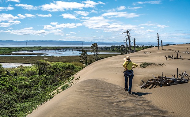
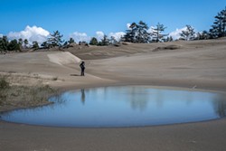
To our happy surprise, just after we began our pandemic-era daily walking, my wife and I discovered the Ma-le'l Dunes North Unit on the Samoa peninsula — a scenic stretch of coastal dunes, forest and tidal lands with few other hikers, and lots of mushrooms and wildflowers.
Part of one of the longest contiguous stretches of coastal dune habitat on the West Coast, the trails in the Ma-le'l Dunes North Unit are open to pedestrian use only — no horses, bicycles or dogs — and is managed as part of the Humboldt Bay Wildlife Refuge by the U.S. Fish and Wildlife Service. One's experience there contrasts in several ways with the Ma'Le'l Dunes South Unit, managed by the Bureau of Land Management, where horses are allowed on trails and wave slope, and dogs must be leashed in the parking area and under an owner's voice control on trails.
Ma-le'l is the place name for one of several Native American villages that existed on the north spit of Humboldt Bay and comes from the Wiyot word Moulu'l, meaning "his house." You will pass a former village site, now buried under a closed down lumber mill, as you turn off State Route 255 onto Young Lane in the northern part of Manila. At the next well-signed T-intersection, turn right to Ma-le'l Dunes North or left to Ma-le'l Dunes South.
The locked gate on the unpaved, bumpy narrow road into Ma-le'l Dunes North is open only Friday through Monday. The Redwood Gun Club firing range on your left provides the occasional gunshot crack (a little unpleasant for hikers). The road ends at a large parking lot with restrooms, picnic tables and the trailhead kiosk, and usually site brochures with maps. We enjoy the North Unit's dunes and solitude so much, sometimes on a Tuesday, Wednesday or Thursday, we'll park at the Ma-le'l Dunes South Unit and walk the extra 0.7 mile past the locked gate to the North Unit trailhead.
We like to arrive at the trailhead at low tide to photograph the patterns in the empty Mad River Slough channels that connect to Humboldt Bay. We also like to visit after winds have smoothed out others' footprints and left pristine patterns in the dunes. During spring and summer, wildflowers are blooming, including golden rod, sand verbena, seaside daisy, beach buckwheat, pearly everlasting, lady's tresses orchids, rattlesnake plantain and the rare Menzies' wallflower. Winter rains bring out an abundance of mushroom varieties, including slippery Jack, redhead russula, false chanterelle and a few fly agaric amanita muscaria.
Trail names here are derived from the Wiyot language and at the parking lot trailhead you enter the Tsoutsgish ("bird") Trail. Just staying on this relatively short out-and-back flat trail built on the old rail bed of the Hammond Lumber Co. Railroad is a good option for anyone looking for an easy walk. With a wall of dunes and forest on the left and the Mad River Slough on the right, the trail ends at the water's edge with great views of wildlife and the remnants of the railroad trestle. Watch on the right for one of the few places with poison oak after you pass the second Dap ("spruce") Loop Trail intersection.
When you're ready for your first visit to the beautiful, giant sandbox in the open dunes (wear "sand shoes"), I recommend creating your own loop walk to help you find the trails' locations. After leaving the parking lot trailhead, turn left on the Kimuk ("whale") Trail and walk up into the open dunes. But instead of following it west to the ocean, turn north and walk cross-country along the dunes, passing large dead trees and the best viewpoint over the dune wall of the Mad River Slough below. Keeping the steep dune wall on your right and after about a half mile, watch for two partially buried Hout Trail signposts next to the dune wall and a line of posts with ropes looping through them that will help you slide carefully down to the T-intersection with the Dap Loop Trail. Going either left or right on it will take you back to the Tsoutsgish Trail (to the right is shorter) and back to the parking lot trailhead. (Hint: You can also reverse this route to acquaint yourself with the trail locations.)
We love walking the Kimuk Trail in April as it passes by large numbers of the rare Menzies' wallflower after you cross the open dunes and follow it to the ocean. We also like to create a loop back to the Tsoutsgish Trail and parking lot by walking north on the ocean wave slope and watching carefully for a large signpost on the crest that marks the entrance to the Hout ("surf fish") Trail. Follow it back east through scrub-covered dunes and look for trail markers the open dunes area here including one on the top of the tallest dune as you return to the roped-up posts located on the dune wall down to the Dap Loop Trail.
Warning: If you keep walking north while enjoying the deserted beach past that Hout Trail signpost on the dune crest, you'll soon see signposts for the Lanphere Dunes Unit, which requires permits to enter. More than a few North Unit hikers have missed seeing the Hout Trail signpost and entered the Lanphere Dunes Unit here to head inland. I recommend returning to the beach and retrace your steps looking for the Hout Trail signpost into the North Unit.
Some days, we just walk the Tsoutsgish Trail to the Dap Loop Trail sign to follow its easy walk with some stairs that help you go up and down the forest-covered dunes. We love the reindeer moss and bear berry here, along with huckleberries in late summer. The Dap Loop Trail also has a flat, out-and-back trail option to the edge of the Mad River Slough called the Viqhul ("salal berry") Trail — you're more likely to find lots of huckleberries here and very few people.
Kudos to all those behind efforts to eliminate beachgrass and other invasive plants, as well as remnants of farm fencing and other man-made objects, to help restore the dune ecosystem. And cheers to those signing up for the restoration ahead in the foredunes area of the Friends of the Dunes Humboldt Coastal Nature Center property to the south and the newly added Waduhl Unit north of Lanphere in the Humboldt Bay Wildlife Refuge.
Mark Larson (he/him) is a retired Cal Poly Humboldt journalism professor and active freelance photographer who likes to walk.
Comments
Showing 1-1 of 1
more from the author
-
The Sawdust Flies at the Conclave
- Mar 21, 2024
-
Once More into the Bay for the Perilous Plunge
- Mar 14, 2024
-
Photos: Humboldt Marble Weekend
- Feb 14, 2024
- More »
Latest in Get Out
Readers also liked…
-
A Walk Among the Spotted Owls
- Apr 27, 2023
