Photo by Mike Peel via Creative Commons
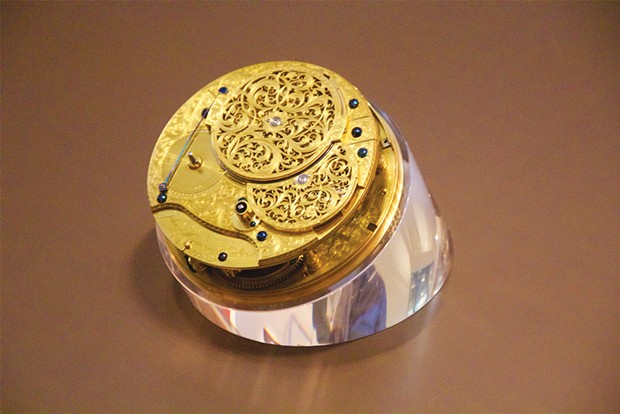
John Harrison's H4 marine chronometer or "sea watch."
[

      {
        "name": "Top Stories Video Pair",
        "insertPoint": "7",
        "component": "17087298",
        "parentWrapperClass": "fdn-ads-inline-content-block",
        "requiredCountToDisplay": "1"
      }

    ]
For 2,000 years, since the time of Greek geographer Claudius Ptolemy, we have defined our position on Earth by two numbers. Latitude tells you how far you are from the equator, measured in degrees, 0 to 90, north and south. Longitude is your angular distance from an imaginary "meridian" line drawn from pole to pole, running through the Royal Observatory, Greenwich, outside London, England. It's also measured in degrees: 180 degrees west of Greenwich and 180 east for the full 360 degrees. (Why 360? Blame the Babylonians.)
It's comparatively easy to reckon one's latitude. Earth's axis points to two imaginary "celestial poles" in the sky. North of the equator, the north celestial pole is close to the North Star. Measure the angle from your horizon to that virtual point in the sky and you've got your latitude. (It's zero at the equator, where the north celestial pole is on the horizon and 90 degrees at the north pole, where it's directly overhead.)
Longitude is a much trickier proposition. Consider a point on Earth where local noon (the sun at zenith) is exactly eight hours later than at Greenwich — Lake Tahoe fits the bill. Eight hours is one third of a full day, which converts to one third of the full 360 degrees, that is, Lake Tahoe is at longitude 120 degrees west. So if you know the time difference between your local noon and local noon at Greenwich, you've got your longitude. The challenge navigators have wrestled with for centuries can be simply stated: What time is it in Greenwich? Nowadays, GPS gives anyone with a receiver — or smartphone — that information. Formerly, radio signals, chronometers and the stars were used. I'll be focusing on the last one.
Radio. The U.S. Navy began broadcasting "Greenwich time" signals in 1905 and the rest of the world quickly followed. Earlier — 1872 — surveyor John Wesley Powell had used a telegraph line to confirm his longitude near the Grand Canyon using time signals received nearly instantly from Salt Lake City where Greenwich time was tracked.
Chronometers. Before radio, navigators would carry an accurate timekeeping device set to Greenwich time. John Harrison's 1759 marine chronometer, dubbed "H4," solved the wickedly difficult problem of keeping accurate time on a rolling ship at sea. As anyone who drives a car or uses a washing machine knows, mechanical devices can fail, hence the navigators' adage, "Never go to sea with two chronometers, take one or three." If you have three and one shows a different time from the other two, ignore it; if you have two and they show different times, which one do you trust? Marine chronometers — HMS Beagle carried 22 — were hugely expensive, and impractical for land explorers such as Lewis and Clark. (Lewis had obtained an English chronometer in Philadelphia but it wasn't reliable when traveling over land for long periods, and he just used it as a watch to connect the time periods between astronomical sightings taken over a few days.)
Celestial navigation. As long ago as 150 B.C., Hipparchus of Nicea wrote that lunar eclipses (which happen at roughly the same time for all Earth-bound observers) could be used to establish longitude. Of the many "clocks" in the night sky, some of the most accurate are eclipses of Jupiter's four bright moons. Galileo, who discovered these moons in 1610, realized that an eclipse of one of them, say, Io, could be clocked simultaneously by observers at two places on Earth, thus giving their relative longitude. In 1668, Italian astronomer Giovanni Domenico Cassini printed the first tables of Galilean eclipses and, later, working in the Paris Observatory, he published the Connaisance de Temps, an almanac (strictly, an emphemeris) predicting the exact times of the every-other-day eclipses of Io as viewed from a meridian running through Paris. Carrying such an almanac in your pocket was like being in instant communication with a home-base observer.
Next time, we'll look at how early non-Native North American explorers used almanacs to determine their longitude.
Barry Evans ([email protected]) encourages visitors to London to check out the Royal Observatory, Greenwich.
more from the author
-
The Other Evolutionist
- Jul 25, 2024
-
Rise and Fall of the "Sunshine Vitamin," Part Two
- Jul 11, 2024
-
Rise and Fall of the 'Sunshine Vitamin,' Part One
- Jul 4, 2024
- More »

