Friday, January 3, 2020
The Biggest Wave and Bomb Cyclone: A Record-Breaking Year of Wild Weather
Posted By Kimberly Wear @kimberly_wear on Fri, Jan 3, 2020 at 3:57 PM
Looking back at 2019 from a weather standpoint, things were a bit on the wild side at times. So, the Journal reached out to climate specialist Matthew Kidwell in the Eureka office of the National Weather Service, who compiled what he saw as the most notable weather incidents to take place last year.
Along with those events, 2019 hit a record for breaking records, with 18 total set, according to Kidwell, that included 11 high temps and seven minimum temps.
The closest other years were 2004 and 2014, which saw 10 and nine record highs, respectively. But 2013 edged out 2019 to stay in the lead for most minimum records at 10.
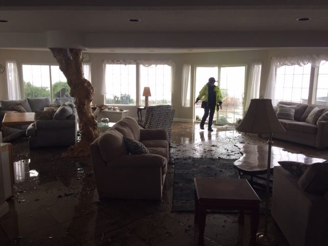
Damaging Waves in Shelter Cove: On Jan. 17, waves upward of 30 feet crashed into eight homes on Lower Pacific Drive in Shelter Cove causing extensive damage, included flooding, mud covered floors, broken windows and ruined furniture.
Cheryl Antony, spokesperson for Shelter Cove Fire, told Redheaded Blackbelt at the time that one of the homes had approximately 10 broken windows and some had up to 4 inches of water inside.
“We had to put life jackets on to walk around [to assess damage],” Antony said. “We have never seen waves like this before. One came over the whole deck we were standing on. We had to run.”
Snow on the Coast: In the early morning hours of Feb. 10, many coastal residents awoke to find a gentle flurry coming down, the likes of which had not been seen since 2002, according to Kidwell.
McKinleyville saw 2 to 4 inches while at least one-half inch blanketed areas of Eureka. U.S. Highway 101 was closed for a time in northern Mendocino County due to snow and rockslides.
While making for some treacherous driving conditions, the rare coastal snowfall sent kids and adults out to enjoy the winter wonderland while it lasted, with many a snowman and snowwoman built that day.
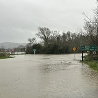
Flooding in February: While it was not at the record-breaking — and heartbreaking — level that the deluge of 1964 wrought, the second month of the year was still marked by heavy rainfall and swollen rivers.
Eureka set rain records on the 25th and 26th and the Ferndale bottoms saw flooding on the 27th, with water levels reaching the highest point since 1986 at Fernbridge, which hit 25.7 feet by 4 p.m.
Humboldt County Sheriff’s Office special services deputies and Search and Rescue Posse members used air boats to help ranchers move their livestock out of the water’s way.
A total of 14.43 inches of rain poured down in February of 2019, the third most on record for the month. Along with the two daily rainfall records, February also saw 24-hour record, with 3.07 inches falling between Feb. 26 and Feb. 27, the most since 2002, according to weather records.
One of the Coldest Months: Along with all that wet, it was also cold. Really, really cold. In fact, February came in as the fifth coldest ever recorded in Eureka, according to Kidwell, hitting the coldest average temperature for the month since 1917.
That included a record low set in Eureka at 29 degrees on Feb. 18, which beat 2006’s record by 1 degree, along with five days of recorded hail as well as the coastal snow flurry.
Hot! Hot! Hot!: Apparently not to be outdone, June followed February’s cold with some blistering hot days, with Eureka hitting 85 degrees on the 11th. There was even a heat advisory on the coast until 7 p.m. while inland temps were upward of 100 degrees.
The day before hit a balmy 71 degrees along the coast with the day after a not-too-shabby and still record-breaking 78.
Many a fan flew off the shelves of local stores during the three-day heatwave and those would prove to be a solid buy as warm temperatures continued throughout the summer months.
Dog Days of August: While there was at least one record-breaking day in August, what stood out the most, according to Kidwell, were the steady warm temps throughout the month thanks to warmer than normal ocean temperatures.
According the NWS records, August tied with 1983 for the warmest average temperature (average of daily max and min) in Eureka of 61.9 degrees. That included the 78 degrees recorded at the Woodley Island office Aug. 21, taking away another title.
Rain Came Pouring Down: With sudden ferocity, a storm cell broke loose over Arcata on the afternoon of Sept. 18, packing a punch that saw some 2 inches cascade down in just one hour in certain places, beating the one-day record for the day of 1.45 inches set in 1977.
According to the NWS, Arcata bore the brunt of the deluge that left flooded streets and water damage at Humboldt State University in its wake — along with a healthy dose of thunder and lightning.
Bomb Cyclone and California's Biggest Wave: Not just a catchy meteorological term, this highly unusual weather event — at least for the North Coast — figuratively exploded over the region Nov. 26, with what is believed to a record low of atmospheric pressure.
The resulting high winds caused widespread damage and power outages during the Thanksgiving week, with wind speeds hitting 69 mph at the Crescent City Airport and 54 mph at the Arcata/Eureka Airport in McKinleyville.
Also generated was a 74.4-foot wave recorded off of Humboldt County’s Cape Mendocino — the largest ever recorded off the California coast, sending the wild weather of 2019 into the new year in spectacular form.
Along with those events, 2019 hit a record for breaking records, with 18 total set, according to Kidwell, that included 11 high temps and seven minimum temps.
The closest other years were 2004 and 2014, which saw 10 and nine record highs, respectively. But 2013 edged out 2019 to stay in the lead for most minimum records at 10.
Damaging Waves in Shelter Cove: On Jan. 17, waves upward of 30 feet crashed into eight homes on Lower Pacific Drive in Shelter Cove causing extensive damage, included flooding, mud covered floors, broken windows and ruined furniture.
Cheryl Antony, spokesperson for Shelter Cove Fire, told Redheaded Blackbelt at the time that one of the homes had approximately 10 broken windows and some had up to 4 inches of water inside.
“We had to put life jackets on to walk around [to assess damage],” Antony said. “We have never seen waves like this before. One came over the whole deck we were standing on. We had to run.”
Snow on the Coast: In the early morning hours of Feb. 10, many coastal residents awoke to find a gentle flurry coming down, the likes of which had not been seen since 2002, according to Kidwell.
McKinleyville saw 2 to 4 inches while at least one-half inch blanketed areas of Eureka. U.S. Highway 101 was closed for a time in northern Mendocino County due to snow and rockslides.

While making for some treacherous driving conditions, the rare coastal snowfall sent kids and adults out to enjoy the winter wonderland while it lasted, with many a snowman and snowwoman built that day.
Flooding in February: While it was not at the record-breaking — and heartbreaking — level that the deluge of 1964 wrought, the second month of the year was still marked by heavy rainfall and swollen rivers.
Eureka set rain records on the 25th and 26th and the Ferndale bottoms saw flooding on the 27th, with water levels reaching the highest point since 1986 at Fernbridge, which hit 25.7 feet by 4 p.m.
Humboldt County Sheriff’s Office special services deputies and Search and Rescue Posse members used air boats to help ranchers move their livestock out of the water’s way.
A total of 14.43 inches of rain poured down in February of 2019, the third most on record for the month. Along with the two daily rainfall records, February also saw 24-hour record, with 3.07 inches falling between Feb. 26 and Feb. 27, the most since 2002, according to weather records.

One of the Coldest Months: Along with all that wet, it was also cold. Really, really cold. In fact, February came in as the fifth coldest ever recorded in Eureka, according to Kidwell, hitting the coldest average temperature for the month since 1917.
That included a record low set in Eureka at 29 degrees on Feb. 18, which beat 2006’s record by 1 degree, along with five days of recorded hail as well as the coastal snow flurry.
Hot! Hot! Hot!: Apparently not to be outdone, June followed February’s cold with some blistering hot days, with Eureka hitting 85 degrees on the 11th. There was even a heat advisory on the coast until 7 p.m. while inland temps were upward of 100 degrees.
The day before hit a balmy 71 degrees along the coast with the day after a not-too-shabby and still record-breaking 78.

Many a fan flew off the shelves of local stores during the three-day heatwave and those would prove to be a solid buy as warm temperatures continued throughout the summer months.
Dog Days of August: While there was at least one record-breaking day in August, what stood out the most, according to Kidwell, were the steady warm temps throughout the month thanks to warmer than normal ocean temperatures.
According the NWS records, August tied with 1983 for the warmest average temperature (average of daily max and min) in Eureka of 61.9 degrees. That included the 78 degrees recorded at the Woodley Island office Aug. 21, taking away another title.
Rain Came Pouring Down: With sudden ferocity, a storm cell broke loose over Arcata on the afternoon of Sept. 18, packing a punch that saw some 2 inches cascade down in just one hour in certain places, beating the one-day record for the day of 1.45 inches set in 1977.
According to the NWS, Arcata bore the brunt of the deluge that left flooded streets and water damage at Humboldt State University in its wake — along with a healthy dose of thunder and lightning.
Bomb Cyclone and California's Biggest Wave: Not just a catchy meteorological term, this highly unusual weather event — at least for the North Coast — figuratively exploded over the region Nov. 26, with what is believed to a record low of atmospheric pressure.
The resulting high winds caused widespread damage and power outages during the Thanksgiving week, with wind speeds hitting 69 mph at the Crescent City Airport and 54 mph at the Arcata/Eureka Airport in McKinleyville.

Also generated was a 74.4-foot wave recorded off of Humboldt County’s Cape Mendocino — the largest ever recorded off the California coast, sending the wild weather of 2019 into the new year in spectacular form.
Speaking of...
-
UPDATE: Artillery Shell Deemed Safe in Ferndale
Apr 12, 2024 -

One Killed, Another Injured in 101 Crash
Apr 2, 2024 -
UPDATE: Local Emergency Declared Due to Storm Damage
Jan 15, 2024 - More »
Readers also liked…
About The Author
Kimberly Wear
Bio:
Kimberly Wear is the assistant editor of the North Coast Journal.
Kimberly Wear is the assistant editor of the North Coast Journal.
more from the author
-
Dust to Dust
The green burial movement looks to set down roots in Humboldt County
- Apr 11, 2024
-
Our Last Best Chance
- Apr 11, 2024
-
Judge Rules Arcata Can't Put Earth Flag on Top
- Apr 5, 2024
- More »


