|
 
IN
THE NEWS | OPINION
| CALENDAR

by KEITH EASTHOUSE
"Whiskey's
for drinking; water's for fighting."
-- MARK TWAIN
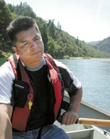
THE SPRING CHINOOK LAY BELLY-UP
IN SHALLOW WATER, bobbing up and down rhythmically as if the
Trinity River had rocked it gently
to sleep. But this, clearly, was not sleep.
"It was coming back up
the river. It would have spawned in September," said Mike
Orcutt, senior fisheries biologist with the Hoopa Valley Tribe. [photo below right]
Looking down at the silver-white
fish on a sunny July morning, the water appeared clear as glass.
But looking out at the river itself, the water, through the trick
of light refraction, appeared blue-green. It looked almost tropical.
Orcutt and his two passengers
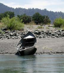
piled into a steel-hulled boat and moved out into the current.
Within minutes the craft scraped bottom. The harsh grating sound
surprised a flock of turkey vultures that had been feeding on
something on the bank -- another dead salmon?
 Orcutt
said he first heard reports of dead fish in the river a few weeks
before. "It happened last year, too," Orcutt said,
adding that it's not clear what's killing them. Rising water
temperatures, always a problem in the summer, may be making them
more prone to disease or parasites. Orcutt said it's possible
nothing out of the ordinary is going on, that the "pre-spawning
mortality," as he put it, is simply more noticeable because
the salmon run this spring was sizeable. Orcutt
said he first heard reports of dead fish in the river a few weeks
before. "It happened last year, too," Orcutt said,
adding that it's not clear what's killing them. Rising water
temperatures, always a problem in the summer, may be making them
more prone to disease or parasites. Orcutt said it's possible
nothing out of the ordinary is going on, that the "pre-spawning
mortality," as he put it, is simply more noticeable because
the salmon run this spring was sizeable.
"The typical [mortality]
level might be 1 percent per year, so if the run is big you're
going to see more dead fish."
Might salmon be dying because
large portions of the river's flows are dammed and diverted southward,
to farmers in the Central Valley? In other words, isn't the river
lower -- and therefore warmer -- than it would be at this point
in the summer if no diversions were taking place? Orcutt doesn't
answer the question directly, perhaps because he knows that flows
on the unregulated Trinity varied widely and could drop to a
trickle from late July through the end of September.
But he does say this: "We've
created an artificial system here that may be making the fish
more vulnerable."
A
pivotal hearing
The artificial system of the
Trinity River, and to what extent it should be restored to its
natural state, has been under debate for more than two decades
-- and there is no resolution in sight.
"I don't foresee an end
to this in the near future," said Tom Stokely, a planner
with Trinity County and a key player in efforts to restore the
river. "I'm 47 and I expect to be working on this until
I retire."
The latest chapter of the Trinity
saga will unfold in a federal courtroom in Fresno next Tuesday,
when U.S. District Court Judge Oliver Wanger hears arguments
in a case that is widely viewed as pivotal to the future of the
Trinity River. At issue is a lawsuit filed in late December 2000,
just days after then-Interior Secretary Bruce Babbitt signed
a years-in-the-making restoration plan for the Trinity.
More water for the Trinity lay
at the heart of the plan. Babbitt ordered that no more than 52
percent of the river's water could go to the Central Valley --
a significant drop from the 75 percent that had been diverted
for much of the 1980s and 1990s, and a sea-change from the 1960s
and 1970s, when up to 90 percent of the Trinity was sent south
every year.
 Not surprisingly, farmers fought Babbitt's order.
Westlands Water District, which has used Trinity River water
to develop a multibillion-dollar agricultural economy, filed
a legal challenge. It was later joined by the Sacramento Municipal
Utility District (SMUD), which stands to lose as much as $2 million
in electricity generated by Trinity powerhouses. Not surprisingly, farmers fought Babbitt's order.
Westlands Water District, which has used Trinity River water
to develop a multibillion-dollar agricultural economy, filed
a legal challenge. It was later joined by the Sacramento Municipal
Utility District (SMUD), which stands to lose as much as $2 million
in electricity generated by Trinity powerhouses.
Last year, Wanger, who has a
reputation for favoring agricultural interests, applied the brakes
to Babbitt's "record of decision." He said the Interior
Department didn't look closely enough at how the plan might affect
power generation. He also said the department didn't properly
study how keeping more water in the Trinity might affect imperiled
fish species in the San Francisco Bay Delta.
Wanger ordered the government
to fix these shortcomings. He allowed parts of Babbitt's plan
to go forward -- such as projects to restore fish habitat and
raise bridges downstream of Lewiston Dam to make way for higher
flows. But he postponed a decision on the higher flows themselves,
without which, many believe, much of the rest of the plan cannot
work.
It is the issue of the flows
-- whether to give the Trinity more water now, as called for
in the Babbitt plan, or to study the matter further, as farming
and power interests are demanding -- that Wanger is expected
to rule on, either at next week's hearing or shortly thereafter.
Wanger has already made one
decision this year regarding flow levels in the Trinity.
Because last year was a drought
year, he had capped the flows allotted to the Trinity at 368,000
acre-feet -- the amount allowed in a "critically dry water
year" under the Babbitt plan and slightly more than the
minimum the river was getting prior to the plan. Last year's
limit would have remained in place this year, even though this
was a normal year in terms of precipitation, were it not for
the Hoopa tribe, which petitioned Wanger to give the Trinity
the amount called for in Babbitt's plan in a "normal water
year" -- 647,000 acre-feet of water (an acre-foot is the
amount of water necessary to cover an acre of land in a foot
of water).
Wanger balked at that. But in
a decision at the end of April, he did agree to allow an additional
100,000 acre-feet of water -- 32.5 billion gallons -- to go down
the river this year, bringing the Trinity's 2002 allotment to
468,000 acre-feet.
The Hoopa tribe's victory, if
that's what it was, could be short-lived. SMUD has come forward
with a proposal that, in the view of critics, amounts to a maintenance
of the pre-record of decision status quo -- significantly lower
flows than called for by Babbitt and restoration projects that
rely heavily on mechanical methods, such as dredging, to improve
fish habitat.
Arlen Orchard, an attorney with
SMUD, said Babbitt's plan is based on flawed science. "There
are other [proposals] out there that provide a more balanced
approach that will result in increased flows and fish restoration
but at the same time will not have quite as big a detrimental
effect on downstream water users," Orchard said in a recent
telephone interview from his Sacramento office.
Stokely of Trinity County, who
was heavily involved in developing the planning documents that
support the Babbitt plan, said the SMUD approach has already
been studied. "It didn't cut the mustard," Stokely
said.
False
assurances
The Trinity River controversy
dates back to the early 1950s, when a string of public hearings
was held regarding a government plan to dam the river and send
some of its water over the mountains and down into the Sacramento
Valley. Irrigators supported the proposal, as did hydropower
interests. Concerns were raised about the impact on the river's
salmon and steelhead fishery. But then-Congressman Clair Engle,
who was on the verge of making a successful run for the U.S.
Senate and needed the support of California's powerful agriculture
industry, assured voters in the north that "the Trinity
project does not contemplate diversion of one bucketful of water
which is necessary in this (the Trinity) watershed."
An official with the U.S. Bureau
of Reclamation, the agency that would build the dams that would
make the diversion possible, went so far as to claim that the
"fisheries would be improved" by the project.
The 1955 legislation that created
the "Trinity River Division" of the Central Valley
Project, a vast water collection and power generating network
that to this day is critical to the state's farming and energy
interests, directed the Interior secretary "to adopt appropriate
measures to ensure the preservation and propagation of fish and
wildlife."
The next year, the reclamation
bureau told Congress that no more than 56 percent of the Trinity's
water would be diverted to the Central Valley Project.
Seven years later, in 1963,
after the completion of Trinity and Lewiston dams and of the
Clear Creek diversion tunnel, which funnels Trinity River water
into a reservoir near Redding, these assurances were revealed
to be nothing more than empty words. The reclamation bureau,
which had just signed a water-delivery contract with the Westlands
Water District in the San Joaquin Valley, promptly began diverting
90 percent of the river's water and continued to do so until
the early 1980s.
By the late 1960s it was becoming
clear that fish populations were in serious decline. By 1977
so much water was being sent to irrigators that Trinity Lake,
the reservoir formed by Trinity Dam, was drained to 10 percent
of its capacity. "They hardly let water out of the dam"
and into the river, recalled Stokely. "It was an extreme
[water] temperature emergency. Thousands of fish were dying.
It was a catastrophe."
Showing
that fish need water
How was the reclamation bureau
able to send so much water to the Central Valley and leave so
little for the Trinity basin -- particularly since Congress had
instructed the executive branch to protect the basin's fish populations?
According to Tom Schlosser,
a lawyer representing the Hoopa tribe, the answer lies in the
language of those instructions. Despite all the assurances, in
congressional proceedings and from politicians, that the Trinity
and its fish populations would not be deprived, the 1955 act
gave the bureau a virtual free hand in two ways: It allowed the
agency to release as little as 150 cubic feet of water per second
to the river ("a trickle," according to Schlosser);
and it qualified its requirement that the fishery be protected
by directing the Interior secretary to take only "appropriate
measures."
Schlosser said this put "on
the fisheries agencies and the tribes the burden of showing what's
needed to protect the fish."
"The Bureau of Rec's view,"
Schlosser continued, "was that all we have to do is the
minimum -- 150 cfs -- until you show us something else is appropriate.
To go above [that] one had to show the fish needed water."
Schlosser said "it took
a few years" for scientists from the California Fish and
Game Department and the U.S. Fish and Wildlife Service to do
just that -- "and [it] took decades for the bureau to comply"
and start releasing more water to the river.
Byron Leydecker, founder of
the group Friends of Trinity River and a vocal critic of the
diversion project, said that the 90/10 diversion ratio "happened
in my opinion because the bureau doesn't pay any attention to
the law." He also noted that no one at the time sued.
That last point jibes with something
that Floyd Dominy, a retired reclamation bureau commissioner
who spearheaded the Trinity project, told the Sacramento Bee
in a recent interview. "Back in our day, we didn't have
the naysayers," said Dominy, now 92. "We didn't have
this Endangered Species Act. Everybody thought the projects were
beneficial and in the national interest."
Challenging
the bureau
Trinity County was one of the
first naysayers, taking the reclamation bureau to court in the
late 1970s after the near draining of Trinity Lake and the fish
debacle.
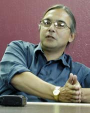 Another
was the Hoopa tribe, which became incensed after Indian fishermen
were blamed for the crashing fish populations. And not just blamed.
"The Indian fishermen who continued to exert their right
to fish got pounded into the sand and were arrested by federal
marshals," recalled Clifford Lyle Marshall, chairman of
the Hoopa Valley Tribal Council [photo
at left]. A subsequent, three-year
government study found that Indian fishing was having a minimal
impact and identified three reasons for the disappearance of
the fish: the diversion of water from the dams, erosion from
logging and overfishing in the ocean. "We were exonerated
in three years," Marshall said. "That was the first
battle. After that, we decided we wouldn't get caught again without
our own science." Another
was the Hoopa tribe, which became incensed after Indian fishermen
were blamed for the crashing fish populations. And not just blamed.
"The Indian fishermen who continued to exert their right
to fish got pounded into the sand and were arrested by federal
marshals," recalled Clifford Lyle Marshall, chairman of
the Hoopa Valley Tribal Council [photo
at left]. A subsequent, three-year
government study found that Indian fishing was having a minimal
impact and identified three reasons for the disappearance of
the fish: the diversion of water from the dams, erosion from
logging and overfishing in the ocean. "We were exonerated
in three years," Marshall said. "That was the first
battle. After that, we decided we wouldn't get caught again without
our own science."
The county and the Hoopa tribe,
along with the Yurok Tribe, which has land northwest of the Hoopa
reservation, were instrumental in persuading Cecil Andrus, Interior
secretary under President Carter, to order, in 1981, that a 12-year
"flow study" be undertaken to determine how much water
would be needed to rejuvenate the fisheries. The county and the
tribes also played a critical role in pushing Congress to pass,
in 1984, legislation that mandated "restoration of fish
and wildlife populations levels to those which existed immediately
preceding construction of the Trinity Division."
The problem back then, and to
this day, was that there never was enough water given to the
Trinity to accomplish the goal of restoring fish populations.
For example, Andrus, in a foreshadowing of Babbitt's plan, directed
that water flowing into the river be increased by varying amounts.
But his mandated flow increases never took place because of emerging
drought conditions.
Flows were finally increased
in 1991, when Interior Secretary Manuel Lujan, in response to
a petition from the Hoopa tribe, ordered that the minimum flows
in the river be increased to 340,000 acre-feet.
The next year, the 1992 Central
Valley Project Improvement Act ordered the Interior secretary
to determine by the end of 1996 the flows required to restore
the river. Babbitt missed this deadline, finally meeting it four
years later at the tail end of the Clinton administration.
Failed
restoration
In the 1980s, a new phase began
in the Trinity fight, one that centered on projects to restore
the river's fish populations. To understand these projects, it
is first necessary to understand the extent to which the Trinity,
which once offered superb spawning and rearing habitat, had become
inhospitable to fish.
First and foremost, the two
dams completely blocked access to the best the river had to offer
-- over 100 miles of cold water salmon and steelhead habitat
above the two dams. That forced the lower river, in particular
the 40-mile stretch below Lewiston Dam, to take on the role of
providing salmon and steelhead with the habitat they need to
grow when they are young and spawn when they reach the end of
their life cycle.
It was originally thought that
the loss of the upper Trinity could be compensated for by installing
a fish hatchery at the Lewiston Dam -- and to some extent this
has been proved true. According to Joe Polos, a fisheries biologist
with the U.S. Fish and Wildlife Service, the hatchery has been
"integral in sustaining downstream populations. In some
years a majority of the fish spawning in the river are hatchery-produced,"
Polos said.
But while the hatchery has helped
prevent Trinity salmon and steelhead from disappearing altogether,
it has not made possible healthy populations. While there is
not extensive data on predam fish populations, Polos said the
best scientific estimate is that fish populations on the Trinity
today have declined about 90 percent from what they were when
the river was wild.
The reason the hatchery hasn't
had more of an effect is simple -- dumping more fish into the
river didn't address the habitat problem.
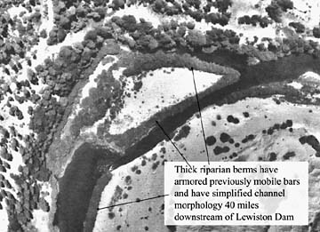
The diversion has robbed the
river of the high flows that scour out the channel and form the
cool, deep pools preferred by the fish. iPredam peak flood levels
were as high as 100,000 cubic feet per second. Today, the highest
flows from the Lewiston Dam are on the order of 6,000 cubic feet
per second.
Several things have happened
in the absence of powerful floods, most notably the creation
of what are known as "riparian berms." The natural
Trinity would move back and forth horizontally depending on how
much water was in the river, creating back channels that were
ideal for young fish to hang out in and grow before they move
down the river and into the ocean. When the flows dropped permanently
because of the diversion, those back channels disappeared. Even
worse, willow seedlings and other vegetation that used to get
routinely swept away by high water now had nothing to block their
growth. The river got "channelized," as Scott McBain,
an Arcata-based consultant who is an expert on river restoration,
put it.
Many of the restoration projects
have focused on mechanically removing the vegetation armoring
the banks. According to Leydecker, a vocal critic of the restoration
effort, the majority of the projects failed for a simple reason:
The flows weren't large enough to prevent a new generation of
vegetation from re-establishing itself.
Another type of restoration
work has to do with addressing the fact that many of the gravels
that are ideal for spawning are intercepted by the dams and never
make it to the lower river. The solution has been to dump gravel
at strategic locations. Here again the results have been less
than successful and for the same reason -- not enough water,
in this case to transport the gravel downstream.
Leydecker is concerned that
history is going to repeat itself. Babbitt's plan calls for more
than 40 restoration projects over the next seven to nine years
on the part of the river below the Lewiston Dam. Judge Wanger
has ruled that those projects can go forward. If they do go forward,
but without the flows designated by Babbitt, Leydecker said the
restoration effort will continue to be futile -- and might very
well be harmful. "If they're going to be running tractors
around in there in the absence of water, I'm concerned they're
going to ruin the damn river."
Doug Schleusner, the reclamation
bureau official who is heading up the restoration work, acknowledged
that getting the flows Babbitt called for is important. But he
said that the restoration program will be flexible and will adapt
as needed. "If it turns out the science says we can't reliably
expect the flows to be sufficient, then we wouldn't go that way.
If we do believe we have enough water going down the river, then
maybe this is an opportunity to test our restoration techniques."
Schleusner said that there are
some projects, such as certain "gravel introduction"
efforts, that can "proceed regardless of flows."
McBain said the 12-year flow
study that was initiated in the 1980s has already shown that
the flows the river has been getting aren't sufficient to allow
the restoration work to be successful. He said it's an open question
whether the flows Babbitt outlined will be enough.
PRE-DAM CHANNEL
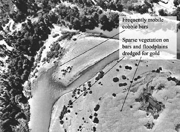
POST-DAM CHANNEL
Images courtesy of McBain
& Trush
 'An Indian playground' 'An Indian playground'
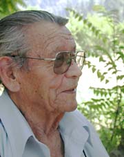
Like Dominy, the retired reclamation
bureau czar who made the Trinity diversion project possible,
Jimmy Jackson is 92 years old [photo
at left]. But that's probably all
he has in common with Dominy, a man considered by environmentalists
to be an arch-villain for his role in a slew of dam projects
in the 1950s and 1960s -- most notoriously the construction of
Glen Canyon Dam, which drowned an extraordinarily beautiful and
labyrinthine desert canyon in southern Utah.
Jackson, an elder with the Hoopa
tribe, remembers that when he was young there were "fish
all over the damn place" in the Trinity. "There were
a lot of deep holes" for the fish, Jackson said during an
interview at his home on the Hoopa reservation. "Now all
the gravel has piled up and filled all our deep holes."
A lively man with a sharp sense
of humor, Jackson is defiant, not defeated, when he talks of
the river. "`Normal flows,' the white man calls it,"
Jackson said, an edge of scorn in his voice. "They cut us
off and took our water. They killed our fish. That was our food."
The river provided something
else to the tribe, Jackson said: a sense of sacredness that is
still expressed by the numerous ceremonies the tribe holds along
its banks. "It's a wonderful thing, that river. It's an
Indian playground. It's just like a church."
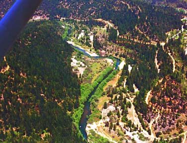
Above: aerial view of the Trinity River
Below: Map of Trinity River overview
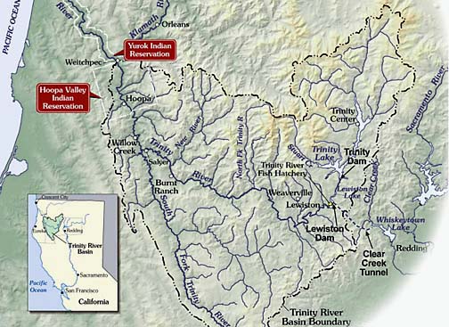
Images courtesy of McBain
& Trush
IN
THE NEWS | OPINION | CALENDAR
Comments? E-mail the Journal: ncjour@northcoast.com
© Copyright 2002, North Coast Journal,
Inc.
|