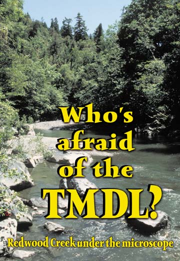
|
by JIM HIGHT
Simpson Timber Co., Sierra Pacific Industries, Barnum Timber Co. and a half-dozen smaller companies could be the first in Humboldt County to feel the law's effect. The U.S. Environmental Protection Agency (EPA) says the timber-harvest operations of those companies in the Redwood Creek basin are polluting water with sediment and harming salmon. State authorities are developing a new action plan to regulate activities on private property in the watershed. Redwood Creek landowners dispute the EPA's view. They say salmon are suffering from damage done before state forest-practice rules were established in the 1970s. They're working voluntarily to erase this legacy, and a study of juvenile fish populations conducted last summer indicates that the rate of decline of some salmonid species may be lessening. But conservation and fishing groups agree with the EPA's verdict, and they believe that the companies' voluntary clean-up efforts will only be effective if the law keeps pressure on them. "Without that, what is their incentive?" asked Vivian Bolin, watershed conservation director for the Pacific Coast Federation of Fisherman's Associations (PCFFA). Conditions in other North Coast river systems will soon be reviewed under section 303(d), and people on all sides of the fish vs. timber conflicts are paying attention to what happens on Redwood Creek. Some conservationists want officials to use the law to further restrict private land uses that affect salmon, while people who own and manage timber and ranch lands are aggravated -- to put it mildly -- at the prospect of operating under a new layer of regulations. "As a landowner I am willing to be involved and listen to reason," wrote Mattole rancher Sterling McWhorter in a June 1, 2000 letter to Humboldt Beacon about 303(d). "However, myself and others will not allow governmental domination over our property rights, livelihood and heritage." This view is echoed in the legal strategies of the California and American farm bureaus, which are challenging EPA's jurisdiction over water-quality standards for forestry and agriculture. The landowner groups may also find some relief from the incoming Bush Administration.
Regulatory giant awakened Under section 303(d), state agencies and the EPA must identify polluted bodies of water and establish for each one a "total maximum daily load" (TMDL) of pollutants that can enter the water without making it unsafe for humans or fish. This section was dormant for many years while water-quality agencies focused on controlling the more obvious "point sources" of pollution -- primarily industrial waste and sewage. The water agencies also lacked money and staff to do the TMDL analyses, which involve quantifying pollution from diverse "nonpoint sources," such as runoff from roads, farm fields and forests. Advocates for conservation and clean water believed that the agencies did not have a choice but to enforce the law, and federal judges in dozens of jurisdictions have agreed. On the North Coast, PCFFA and the Northcoast Environmental Center were among the groups that sued the EPA to enforce section 303(d). "We saw this as a way to encourage landowners to protect and restore freshwater salmon habitat," said Bolin. Under a consent decree, EPA agreed in 1997 to develop and complete TMDL analyses for North Coast rivers, starting with Redwood Creek. EPA's authority ends with the TMDL report, however. Now the North Coast Regional Water Quality Control Board is in the driver's seat and must develop a Water Quality Attainment Action Plan for the basin. The regional board released a draft action plan in December 1998, but withdrew it to review issues raised by scientists and the landowners. 1990 aerial photo
of Redwood Creek showing the sediment deposited in the 1964 flood.
Polluted by sediment Redwood Creek, says the TMDL report, is polluted with sediment -- soil, gravel and rocks that erode downhill from private land into the river's tributaries and main stem during rainstorms. How can natural erosion and sediment be considered pollution? The relationship between sediment and salmon is complex. Sediment transported by flowing water forms the fishes' habitat, the gravel beds where adult females deposit their eggs and the riffles that oxygenate the water for the emerging young fish. When large trees topple and get wedged into sediment in a stream channel, the water scours out pools where young salmon can find refuge from birds and from hot temperatures in summer and high winter flows. In the steep and unstable Coast Range mountains, streams and rivers collect great quantities of sediment naturally, and salmon have evolved to spawn, hatch and survive in sediment-rich environments. But due to logging and other human activities, erosion has accelerated far beyond natural "background" rates in many watersheds of the Pacific Northwest. Scientists think these excessive sediment loads are one of the significant factors limiting salmon's ability to reproduce and contributing to the decline of the species. In Redwood Creek, "Accelerated erosion from land use practices and other causes is impacting the migration, spawning, reproduction and early development of cold water anadromous fish such as coho salmon, chinook salmon and steelhead trout," states the TMDL report. "Land management patterns and practices have contributed to increased erosion beyond natural rates through mass wasting (landsliding) and fluvial erosion (gullying and stream bank erosion)." As a result, gravel beds in the tributaries and main stem are covered with too much fine sediment to be of use for spawning. The main stem lacks "an adequate pool-riffle structure" for oxygenation and habitat. And so much coarse sediment has been deposited there that in the summer, much of the water flows "subsurface" through the columns of gravel and cobble-sized stones, leaving in many places a slow-moving trickle that becomes too hot for coho salmon. Since most of the sediment is coming from "improperly designed and maintained roads and skid trails, and timber harvest," EPA's prescription -- the heart of the TMDL report -- is for landowners to reduce the sediment from their land by as much as 60 percent.
Landowners respond Members of the Redwood Creek Landowners Association (RCLA) have responded to the agencies with two different strategies, one focused on public relations and the other on technical presentations to the regional water board and its staff. For public relations, the landowners association published a 50-page booklet last year expressing the viewpoint, one shared by many in the wood products industry, that sediment problems are given too much weight when the causes of salmon decline -- in Redwood Creek and elsewhere -- are measured.
While the authors of A Study in Change: Redwood Creek and Salmon claim to represent data from more than 500 "geologists, fluvial geomorphologists, hydrologists fisheries biologists" and other sources, other scientists reviewing it say it falls short of good science. "They say that because sediment is being flushed out of Redwood Creek at one of the highest rates of any river in the U.S., this is a sign of good health," said Mary Ann Madej, a research geologist for the U.S. Geological Survey, who has published numerous scientific papers on Redwood Creek. "I liken this to a doctor who says that it is a positive sign the patient is bleeding profusely because it shows his circulation is healthy." Madej and other sources say that the authors of A Study in Change misrepresent some of the studies they cite in the report to support their conclusion that man-made sediment is not adversely affecting salmon production in Redwood Creek. "We know that a lot of the people we're quoting would not agree with what we're saying," explained Steve Horner, a Barnum forester and RCLA spokesman. "There's a difference between data and conclusions. Everybody can draw different conclusions. We acknowledge we're taking a different outlook on this, but we think our outlook is absolutely defensible."
"I don't think the issue is whether [the TMDL analysis] is accurate or not," said Tom Walz, district manager for Sierra Pacific Industries. "The issue is, can we find ways to reduce the existing erosion potential so that we'll have nothing but improvement occurring." "The water quality board has met with landowners and we've expressed our desire to see a plan that is based on finding the problems and fixing them," said Walz. "We're saying we can get to the aspects of the technical TMDL [targets] through a voluntary cooperative approach as opposed to a regulatory, prescriptive approach," said Bernie Bush, a Simpson silviculturist and spokesman on the TMDL issue. Bush is not talking about theoretical "voluntary cooperation" but about a landmark collaboration between the landowers and an institution uniquely qualified to deal with erosion in Redwood Creek: Redwood National Park.
Road work ahead In its controversial 1978 expansion, Redwood National Park acquired from timber companies 48,000 acres in lower Redwood Creek. The landscape had been logged intensively, but the biggest problem facing the Park Service was old dirt logging roads.
Roads on the North Coast, as any county engineer can testify, have a tendency to move downhill in winter rains. Before 1983, when forest practice rules were amended to protect streams and guide road construction and erosion control, logging roads were often built without regard for their future erosion potential. Lower Redwood Creek was furrowed with hundreds of miles of abandoned roads -- erosion time bombs set to go off in the next deluge. After some experimentation, Park Service geologists learned that the best way to stabilize and restore the hillsides was to remove road fill from unstable areas with heavy equipment and put it on a relatively flat spot where it wouldn't erode into a stream. Then they would recontour the work areas to approximate natural topography. The tools for this kind of restoration -- excavators, bulldozers and dump trucks -- were the same ones used to build the roads. Former Park Service geologists Danny Hagans and Bill Weaver went on from the Redwood Creek restoration team in 1990 to become private consultants, adapting the park's methods for private landowners who needed to upgrade, not obliterate, their roads. Many resource managers have learned the practical science of "erosion-proofing" timber and ranch roads. And in Redwood Creek, landowners began this kind of erosion-control work as early as 1993. But their efforts really took off in 1995 when they worked out a cooperative agreement with the park. The following summer, geologists working for the Park Service and the U.S. Geological Survey trekked across 90 miles of dirt roads on private land in upper Redwood Creek. They found more than 500 places on dirt roads -- abandoned ones as well as currently used ones -- where the potential for erosion during the next big storm was high. The scientists gave a detailed report to the landowners, who did not protest or complain but instead invited the geologists back to do more surveys. "By the end of 2002 we will have the vast majority of roads on private lands in Redwood Creek assessed," said Greg Bundros, research geologist for Redwood National Park. "In the last three years, almost 70,000 cubic yards of potential sediment have been taken out," said Walz of Sierra Pacific. Nonprofit groups such as the Pacific Coast Fish, Wildlife and Wetland Restoration Association are helping with the erosion assessments, and state and federal grants cover 50 to 90 percent of the costs for each erosion-control project, according to sources.
Cooperation vs. regulation With so much voluntary cooperative work underway, the Redwood Creek landowners say there is no need for more regulation of their activities. Their current operations do not contribute significantly to erosion, they say, and they're committed to cleaning up the erosion problems associated with old roads. "We believe the best way to go about dealing with the concerns that some folks have is in a voluntary manner," said Simpson's Bush. "A more top-down or regulatory approach [is] going to put at risk a lot of good cooperative effort. We don't want that to happen. We need to continue to move forward with what we're doing." But PCFFA's Bolin says that history shows it takes regulation to inspire cooperation. "What spurred their cooperation [with Redwood National Park] was the pending list of Redwood Creek as a `sensitive watershed' and an impaired water body under the TMDL," said Bolin of PCFFA. Bolin also notes that a draft action plan for Redwood Creek released by the regional board staff in December 1998 emphasized voluntary measures. Under that draft, "Landowners who submitted a plan for sediment reduction would be relieved from any penalties for continuing habitat degradation from sediment pollution," said Bolin.
Garcia River sets precedent That approach mirrored the precedent set in Mendocino County's Garcia River basin, the first test-case for section 303(d) and TMDL regulations in California. A TMDL study was completed showing sediment impairment, and after some intense negotiations with landowners, the North Coast Regional Water Quality Control Board hammered out an action plan that went on the ground last year. The plan gives landowners three options. Two involve serious restrictions on how they can use their land. But the third -- which virtually every landowner in the basin has chosen -- emphasizes voluntary action like that already occurring in Redwood Creek. "[The Garcia basin landowners] have to inventory all their erosion problems and commit to solving them at a rate of 10 percent per year over a 10-year period," said Dave Evans, senior water resource control engineer. "I think we're in pretty good shape. Everybody is positive," said Walt Stornetta, who owns and operates a 1,000-cow dairy farm in the Garcia River basin. "Bottom line is, it's made us better stewards of the land."
Logging practices questioned Some North Coast conservationists think the regulatory approach used in the Garcia basin won't do enough for Redwood Creek salmon. "We proposed a year ago that [the regional water board] take into account the increased risk of landslides and sediment generation that occurs following timber harvest," said Jesse Noel of Salmon Forever, a group that monitors and restores salmon habitat and advocates for its protection. "There's a myth that if you fix the roads and `storm-proof' them, erosion rates will go to background levels," said Noel. "I believe roads have to be repaired, removed or decommissioned, and that the other controllable factors such as the rate of timber harvest and the extent of canopy removal also has to be considered." In the EPA's TMDL report there is a recommendation to prohibit "clearcut and/or tractor yarding in steep inner gorge, unstable, or streamside areas unless a detailed geological assessment is performed which shows there is no potential for increased sediment delivery to water courses." The regional water board staff is also eyeing this issue as it develops a second draft of an action plan for Redwood Creek. "There are a lot of smaller perched landslides distributed throughout the landscape in Redwood Creek," said Bruce Gwynne, environmental specialist on the regional water board staff. "Heavy logging and the extensive network of roads that were abandoned but never put to bed were followed by large rainfall events in the '50s and '60s. You had a lot of blockages and movements of earth because the drainages had been disrupted. Now, that material is perched at repose. "As proposals are made to operate new harvests through those areas, we're concerned that we need to have a higher level of scrutiny as to the new roads that might go through there," said Gwynne. "There is a difference of opinion with the large industrial landowners as to how much scrutiny the water quality authority should place on roads that would go in for a new round of harvesting." "The regulations we comply with are the forest practice regulations," said Simpson's Bush. "These regulations require that you comply with the North Coast Basin Plan (water-quality standards for all coastal watersheds from Marin County to the Oregon border). The landowners already have to deal with all the obligations in the basin plan, which include waste discharge and sediment." "We aren't really bringing up a new or more strict standard," countered Gwynne. "We're bringing evidence to bear that current standards aren't being complied with."
More TMDL reports coming The next step in the Redwood Creek TMDL process will be the release of another draft action plan for the basin, then a workshop for public comment and a public hearing before the regional board. Then there will be a final hearing before the state Water Quality Control Board. Thirteen other river and creek basins in Humboldt County are considered polluted by EPA and the state and regional water quality control boards. These include the Klamath and Trinity rivers, Mad River, Freshwater Creek, Elk River, Van Duzen River, the five forks and the delta of the Eel River, and the Mattole River. All but the Klamath are polluted by sediment and siltation associated with timber harvest and/or livestock grazing. "Backflow" of fertilizer-laden water from irrigated crop fields is the primary nonpoint source polluting the Klamath. TMDL reports have been developed for the Van Duzen and the South Fork Eel, and others will be underway sometime in the future, followed by action plans. Conservation advocates, landowners and agency staff will certainly be having discussions and arguments similar to those concerning Redwood Creek. IN THE NEWS | GARDEN | ARTS ALIVE! | CALENDAR Comments? E-mail the Journal: ncjour@northcoast.com
© Copyright 2001, North Coast Journal, Inc. |

![[photo of Redwood Creek Tributary]](cover0104-colorinset.jpg) Almost 30 years after the U.S. Clean Water Act
was signed into law, a formerly obscure provision of the act
-- known as section 303(d) -- may soon lead to new restrictions
on Humboldt County timber and ranching operations.
Almost 30 years after the U.S. Clean Water Act
was signed into law, a formerly obscure provision of the act
-- known as section 303(d) -- may soon lead to new restrictions
on Humboldt County timber and ranching operations.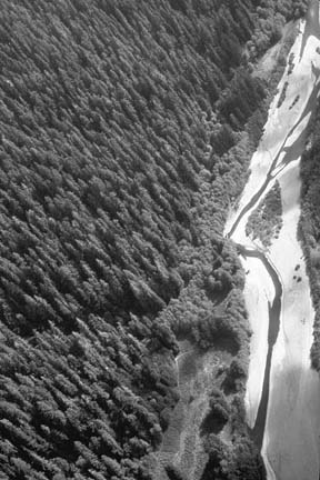
![[photo of report page]](cover0104-report.jpg) The landowners' Study in Change report --
The landowners' Study in Change report -- ![[map of Redwood Creek Basin]](cover0104-map.jpg) When it comes to presenting
information to the regional water board staff, the landowners
present their case much differently -- and with more substance.
In agency workshops, they have not objected to the TMDL analysis,
according to water board staff members.
When it comes to presenting
information to the regional water board staff, the landowners
present their case much differently -- and with more substance.
In agency workshops, they have not objected to the TMDL analysis,
according to water board staff members.![[photo of road failure]](cover0104-roaderosion.jpg) Road
Failures like this one in Lower Redwood
Road
Failures like this one in Lower Redwood ![[photo of Bolin]](cover0104-bolin.jpg)
![[photo of Bush]](cover0104-bush.jpg)
![[photo of Gwynne]](cover0104-gwynne.jpg)
![[photo of backhoe]](cover0104-backhoe.jpg) Restoration equipment is the same
as that
Restoration equipment is the same
as that