 
Sept. 16, 2004
IN
THE NEWS | EDITORIAL | GARDEN | STAGE DOOR
PREVIEW
| THE HUM | CALENDAR
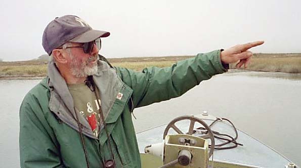
![Lost rivers and ghost towns: Fifty years on the Eel River Delta with Bruce Slocum [photo of Slocum driving boat in river]](cover0916-photohed.jpg)
Cover photo: Bruce Slocum
on the Eel River,
Photo by John Gammon of River Sky Media.
by JIM
HIGHT
THE WATER IN THE EEL RIVER DELTA
IS A GRAY AND GREEN CANVAS painted with endless tiny ripples.
Our boat drifts and turns slowly with the breeze. The cloudy
sky hangs low, and curlews and willets stand on the shore.
Our guide, Bruce Slocum, tells
us that the birds are resting while they wait for the tide to
go out. "Then they'll feed by probing with their long bills
in the mudflats to find little insects and crustaceans,"
he says, gazing at the flock through binoculars.
In the midst of this tranquil
scene, Slocum has destruction on his mind.
 He fires up
the motor and pilots his boat toward the mouth of the river,
then stops when he spots a couple of old wooden pilings in the
water. "That's all that's left of the little town of Camp
Weott," he says. He fires up
the motor and pilots his boat toward the mouth of the river,
then stops when he spots a couple of old wooden pilings in the
water. "That's all that's left of the little town of Camp
Weott," he says.
"It was mostly a summer
recreation area, with hunting and fishing in the fall,"
he says. "But by the early 1950s there were some nice two-story
houses along here." Slocum pulls out photos that show a
jumble of cabins and boats tied up at docks, and an aerial photo
showing the town on a peninsula between two river channels.
He told us the town began to
disappear after the big flood of 1955, which rearranged the lower
Eel so that it began slicing the peninsula into two islands.
Cabins were abandoned or torn down, then the tremendous 1964
flood wiped the islands clean of structures.
"There was still about
an acre of land in back of the pilings here, covered with brush
and trees about 20 feet tall," he says. But in October 1984,
a huge storm and an extraordinarily high tide came together for
a final assault. "The sea was so rough and the tides so
high that 12-foot waves were coming up from the mouth of the
river," says Slocum, pointing west at the ocean, which roared
behind the fog. "[The breakers] shredded all the vegetation
out there, and since then all the original land has eroded completely
away."
It was hard to imagine that
a town had existed in this misty bayou, or that floods and storms
violent enough to wipe it out had pounded this tranquil spot
where we floated.
![[photo of Camp Weott, buildings, boats and docks at river's edge]](cover0916-campweott.jpg)
Before the floods, Camp Weott circa 1915 to 1925.
Photo from Peter Palmquist Collection
But Slocum had lived through
it all, fishing from the public docks in Camp Weott, watching
the river eat the earth out from under the buildings, and even
going out in his boat to retrieve a dock that had busted loose
in the storm that finished off the ghost town.
Slocum, 62, is an eyewitness
to five decades of history in this 10-square-mile network of
sloughs, bays, channels and islands northwest of Ferndale, where
the Eel River meets the Pacific Ocean.
And on his two-hour guided tour,
Slocum weaves his own memories together with centuries, even
millenia, of history -- history he has learned from older residents,
from books and journals, from old maps and back editions of the
Ferndale Enterprise, and from teachers at Humboldt State
University and College of the Redwoods.
 "At
any one place, you're only going to find one guy with that kind
of wide range of knowledge and skills," says Curtis Ihle,
director of the Humboldt County Resource Conservation District,
an agency that works to protect natural resources. "In the
Eel River Delta, he's it." "At
any one place, you're only going to find one guy with that kind
of wide range of knowledge and skills," says Curtis Ihle,
director of the Humboldt County Resource Conservation District,
an agency that works to protect natural resources. "In the
Eel River Delta, he's it."
"Bruce has lived and breathed
the dynamics of the Eel River and the Eel River Delta,"
says, Karen Kovacs, Department of Fish and Game biologist. [photo at right] "And
he has a gentle and effective way of getting a message across
about their value."
GROWING
UP ON THE RIVER
Slocum started his Camp Weott
Guide Service in 1975 because he wanted people to see "how
much neat stuff is out here," he says.
But his love affair with the
Eel River Delta began when he was transplanted to Humboldt County
from Seattle at 10 years of age.
His father, Don Slocum, had
already introduced him to boating and fishing on Washington's
Puget Sound. Soon after the family moved to Ferndale, the elder
Slocum bought a boat, and father and son fished for salmon on
the lower Eel River near Fernbridge.
Young Slocum quickly learned
about the downriver town of Camp Weott, and he often rode his
bicycle there to fish off the public docks that were maintained
by the County of Humboldt.
His ability to travel the delta
increased significantly a few years later when he unearthed an
old redwood seine skiff. Made from thin planks of redwood bent
around a frame, such boats had been the standard vessels of the
river's salmon fishery. With a new plywood bottom and a motor,
Slocum's boat became his ticket to fish and explore up and down
the delta and lower Eel River.
In the catastrophic 1964 flood,
Slocum joined in search and rescue operations. He promptly lost
his boat and almost became a casualty himself. "I was just
outside Ferndale at the Ferndale highway, going to rescue some
people, when my motor got tangled in the new wire fencing,"
recalls Slocum. While his heavier comrade steadied himself in
the current, slightly built Slocum had to pull himself along
the wire fence back to higher ground. "An interesting time
was had by all," he says.
Despite this inauspicious start,
he continued volunteering for search and rescue operations. Today
he is captain of the marine unit of the all-volunteer Sheriff's
Posse Search and Rescue organization.
![[Slocum in boat with birdwatcher with binoculars]](cover0916-birders.jpg) Slocum
worked as a mechanic at local auto and farm shops, and he attended
Humboldt State University for a couple of years. Then he found
a career niche using a skill he'd honed at Ferndale High School:
drumming. Slocum
worked as a mechanic at local auto and farm shops, and he attended
Humboldt State University for a couple of years. Then he found
a career niche using a skill he'd honed at Ferndale High School:
drumming.
"I spent the next 20 years
being a musician," he says. "The farthest I got away
[from Humboldt County] was West Texas. I played either rock and
country, depending on the band. I was kind of a jack of all trades
for music." He still plays today in the classic rock band
Taxi.
But the delta remained his home.
In 1969 he moved to a house on a ranch adjacent to what was then
the delta's main channel. Much later, he moved into his wife
Nancy Kaytis-Slocum's house closer to the mouth of the river.
Slocum's guiding career got
started by accident.
In 1975, birdwatching had a
more limited following in Humboldt County than it does today.
But Slocum knew two brothers, originally from the East, who were
trying to build enthusiasm for birding here. One was his family
physician, Clarence Crane, and the other was, Bill Crane, the
high school band teacher who'd helped Slocum learn drumming.
Exploring the delta one day,
Slocum noticed some snowy owls patrolling the shores for rodents.
He knew the area's winged inhabitants well enough to grasp that
these downy white predators were very unusual visitors, and he
thought the Cranes would want to see them.
He invited the brothers out
in his boat. They were thrilled, and Slocum's interest in birding
was piqued. "They got me to do the [Audubon Society's] Christmas
bird count that year," he says.
"Then I just kind of decided
that since people liked [touring the delta] so much, maybe they
could help me pay for the gas," he says.
Slocum has run his Camp Weott
Guide Service ever since, and he has no plans to stop.
But the part-time business is
slow at best. (Slocum also has a government day job.) Recently,
his tour trade has dropped to a trickle. "This is the slowest
year since I started," he said.
"Almost everybody who goes
out in the boat thinks it's a wonderful thing out here,"
says Slocum. "Finding new people who are interested in seeing
it has always been a stumbling block for the business."
![[Map of Eel River Delta, circa 1940s, depicting area from Eureka to Centerville, Eel River, Salt River, Port Kenyon, Camp Weott, Ferndale, Fernbridge, Fortuna and Arlynda Corners]](cover0916-EelRiverDeltaMap.jpg)
READING
THE WATERY LANDSCAPE
After booking a 1 p.m. tour
with Slocum in mid-August -- the hour being coordinated with
high tide -- I follow his directions through several miles of
dairy farms and cornfields to a small private dock on a piece
of the delta known as Morgan Slough.
Dressed in layers of faded green,
his face shrouded by sunglasses, a salty beard and a baseball
cap, Slocum is not effusive in greeting my companion and me.
But he shows his warm side as he hails some birds. "Hey
guys," he says to a pair of yellowlegs swooping by.
"They winter in the area,"
he explains to us, "and they're just getting here in the
last few weeks, like a lot of the shorebirds."
After we board his 16-foot motorboat,
we push off into the wide, full channel, and Slocum begins to
interpret the watery landscape. "For many years, this was
the main channel of the Eel down through here," he says.
"In 1960, the river cut back of Cock Robin Island over there,
where the tall trees are," he says, gesturing across the
water to the north.
"The main channel was still
here on this side until a big flood in `86 deepened that back
channel," he says. As the river flowed more slowly in this
secondary channel, it deposited more sediment -- the dirt and
gravel which the Eel River transports in prodigious quantities.
Slocum explains that sediment
begets soil, which begets vegetation, which traps more sediment.
He points upriver to a sandy spit of land nearly spanning the
channel, with shrubs and trees encroaching on both sides. Slocum
predicts that the spit will collect more sediment, grow larger,
become more thickly forested and eventually block the river's
flow entirely. "That's typical of what happens with these
old river channels and meanders," he says. "The river
goes somewhere else and leaves them behind."
But at this time of year, this
back channel, the main channel and all the reaches of the delta
are filled by the ocean, not the river. "This is tidewater
down here," Slocum says. "The [water level] goes up
and down twice daily with the ocean tides."
Slocum points to a log dotted
with tiny barnacles. "In midsummer, with the low flows in
the river, it pretty much becomes a salt water bay. You get mussels
and barnacles growing. [Then] invariably, in the winter, all
these plants and animals are killed off by the large flows of
freshwater," he says. "Unlike a true salt water bay,
it has to start its colonies of plants and animals over again
every year. The larvae and the seeds and spores, et cetera, float
in with the tides, [and] every year they're regenerated."
As we ride farther into the
delta, we pass islands thick with willows and alders. On the
shores of the mainland, sedges and rushes line the banks, and
cows, barns and towering cypress trees drift by in a dreamy panorama.
![[Slocum piloting boat, river in background]](cover0916-slocumboat.jpg) Most
of the barns house active dairy operations, but some of the land
has been abandoned by farmers. "A lot of this land right
along the coastline that the pioneers claimed for agriculture
turned out to be too marshy, even though they diked a lot of
it," Slocum says. "The main reason being that even
though the [river] sediments build it up, the earthquakes settle
it back down again." Most
of the barns house active dairy operations, but some of the land
has been abandoned by farmers. "A lot of this land right
along the coastline that the pioneers claimed for agriculture
turned out to be too marshy, even though they diked a lot of
it," Slocum says. "The main reason being that even
though the [river] sediments build it up, the earthquakes settle
it back down again."
Slocum had already shown us
how an earthquake in the year 1700 dropped the land 10 to 12
feet relative to the sea. The evidence: the stump of a spruce
tree almost entirely covered with ocean tidewater.
Now he points to Seaside Island.
Shrouded with willows and alders, the island sits just inland
from a line of dunes that hides the sea. "The north end
of this island settled about a foot and a half in the 1992 earthquakes,"
he tells us.
Once the site of a thriving
dairy, "It's gone pretty much back to its original wild
state, a salt marsh," Slocum says. He tells us that the
island is home to raccoons, otters, skunks, bobcats, porcupines
and a small herd of deer whose members commute from the mainland
by trails or by swimming.
"It's really amazing how
fast a deer can swim with those little feet," he says.
"Years and years ago, there
was a really old buck out here ... I saw him down at the mouth
of the river one time, which happened to be the opening day of
duck season," remembers Slocum. "I guess he was spooked
out by all the duck hunters shooting down here. Anyway, he jumped
into the river and against the outgoing tide swam all the way
up to Camp Weott. Probably close to a mile."
HOPE
FOR THE SALT RIVER
We soon reach a narrow little
slough that was once the navigable Salt River. Two-and-a-half
miles upstream, Slocum tells us, is the site of Port Kenyon,
the 19th-century port where ships called to deliver manufactured
goods and pick up lumber, salmon and farm products. "They
used to bring ships up to 175 feet long up this channel,"
he says. "Hard to believe now."
Today the tidewater falls a
quarter-mile short of the site of Port Kenyon, says Slocum, who
learned this when he surveyed the channel recently for the city
of Ferndale.
Slocum doesn't envision ships
navigating the Salt River again, but he and many others would
like to see the channel reopened to allow salmon to reach the
creeks that drain into the channel and to lessen the flooding
that plagues much of the lower Eel River Valley.
"Salt River is not actually
a river itself," he explains. "It's an old abandoned
channel of the Eel" that once carried water from the mainstem
some eight or nine miles up the valley. "I suspect it had
been abandoned by the Eel not long before [Port Kenyon was established
in the late 1800s] because [the port] was still so deep, 13 feet
at low tide."
If not for a levee built after
the 1964 flood, the Eel River would regularly push water over
its banks and down the Salt River during periods of high flows.
The highest flows still crest the levee, but without the more
regular flushing effect of big water, sediment from the creeks
and from its own eroding banks has filled the Salt River in.
"It's part of the natural
process of sediment filling old river channels that occurs all
across the delta floor," Slocum says. "It's just that
this particular infilling happens to impact the fish and a lot
of people."
With his expertise in the river's
history and behavior, Slocum is an advisor to the Resource Conservation
District, which is planning the Salt River restoration program
along with the U.S. Army Corps of Engineers. He's optimistic
that a fix can be worked out.
"Some are talking about
taking the levee out," says Slocum. "That's undoubtedly
not going to happen. It protects too many ranches at the upper
end."
Instead, he envisions "a
floating dredge starting at the mouth or an excavator moving
alongside the channel. They won't have to take out a huge amount
of dirt ... just enough [to create] a channel so water can flow
down and fish could get up."
![[aerial photo of flood]](cover0916-portkenyonflood.jpg)
ABOVE: Living with big water.
Floods like this one in 1970 frequently inundate the former Port
Kenyon area.
Photo courtesy Genzoli
Collection, HSU Library
A remnant of a pier marks the site of the Port Kenyon dock. Willow
trees now line the path of the Salt River.
![[Photo postcard showing ship on river]](cover0916-saltriverargoPC.jpg)
Ocen-going ships once steamed up the Salt River to Ferndale's
Port Kenyon.
DAMS
AND LOGGING
Discussing sediment and the
Eel River leads inevitably to the question of whether -- or how
much -- Pacific Lumber Co.'s logging practices have increased
erosion in the Eel River watershed, where most of the company's
operations take place.
"It's a point of fact that
they've logged more since the [Maxxam] corporate takeover,"
says Slocum. "How much that has impacted particular areas,
I don't know. It may be that, overall, whatever they're doing
is still less than what was going on in the `50s and `60s, when
there were 150 sawmills and logging companies in the area.
"Because the whole Coast
Range is such a young range, we have a tremendous amount of sediment
coming down the river," says Slocum. "It was like that
before Europeans arrived here, and it will go on for tens of
thousands of years. In the upper watershed, there are a lot of
major slides going right into the river."
Slocum is less agnostic about
the impacts of Pillsbury Dam and the Potter Valley Project, which
take water from the upper reaches of the river's main fork and
divert it to Sonoma County.
"The dam takes 95 percent
of the water out of the Eel River in the summertime. That has
to negatively affect any fish trying to get up there in late
fall before the winter rains raise the river, or smaller fish
coming down in spring," he says. "It is also cutting
off 120 miles of spawning streams past the dams."
While the diversion doesn't
affect the delta -- which is fed by all the river's forks and
filled with ocean tidewater during summer and fall -- Slocum
says, "I'd like to see the dam go away so it would help
the fish. In the 50 years I've been around here, I've seen the
salmon fishing go from real good to nothing."
![[Slocum driving boat onto dock]](cover0916-dock.jpg)
Slocum maneuvers his boat onto the dock after a tour
DELTA
THRIVING
But as we continued our tour,
riding to within about 50 yards of the breaking surf at the river's
mouth, then up the main channel where riparian forests shelter
bustling rookeries from the northwest winds, Slocum explains
that the decline of salmon fishing has had a surprisingly beneficial
effect on the delta.
"It used to be you'd go
over here around Cock Robin island and there'd be 10 or 20 boats
out there, if not catching anything at least drowning worms,"
he says. "Now we're not seeing it. Even on a really nice
day, there's hardly anyone else out here, just the occasional
kayakers and canoeists."
"Compared with even 100
years ago, there's so little use of the area now," says
Slocum. "At the turn of last century Port Kenyon was still
a port, with all kinds of docks and industrial things and canneries."
"I think it's in very good
condition now. There are no particular pollutants, no farming
operations that put a lot of pesticides in the water," Slocum
says. "The dairy waste everybody is concerned about now,
that's being pretty much controlled with waste ponds."
In an ironic bend in Slocum's
own story, the health of his beloved delta has been most improved,
in his estimation, by the destruction of the very community that
he memorializes in his tour.
"The turning point was
losing Camp Weott," he says. "Those people who were
out here fishing, hunting and camping had all kinds of impacts.
"Now it's mostly an untampered-with
ecosystem," says Slocum. "All these areas are growing
up, going back to the way they were before."
Additional Information
For information about booking
an Eel River Delta tour with Bruce Slocum, call 786-4902.
Slocum will present a lecture on the Eel River Delta at 2 p.m.,
Saturday, Oct. 9, at the Eureka Branch Library. Call the Humboldt
County Historical Society at 445-4342 for more information.
For more information about the Salt River, go to www.ebeltz.net/fieldtrips/saltriver.html
Jim Hight is a freelance
writer based in Arcata. He is working with videographer John
Gammon/River Sky Media to produce an educational video documentary
about Bruce Slocum and the Eel River Delta. For more information,
contact Jim at 822-2628 or .
IN
THE NEWS | EDITORIAL | GARDEN | STAGE DOOR
PREVIEW
| THE HUM | CALENDAR
Comments?
© Copyright 2004, North Coast Journal,
Inc.
|