Thursday, September 17, 2020
August Complex Spreads 40K Acres, Forces New Evacuations
Posted By Kym Kemp on Thu, Sep 17, 2020 at 10:25 AM
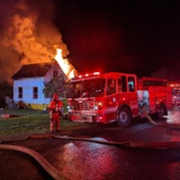
The August Complex, the largest fire in California history, consumed more than 40,000 acres yesterday (more than 60 square miles) and has now charred 839,000 acres and remains only 30 percent contained.
Last night, the fire shot out multiple spot fires to the north of Rattlesnake Ridge and forced new evacuations. “It is a priority of the North Zone to stop the progress north towards Forest Glen and Trinity Pines and Post Mt,” said Karena Davis, spokesperson for team fighting the fire in that area.
Near Ruth the fire moved down along Horse Ridge towards residences in the area but with the moisture in the air is expected to be slow and easy and allow the firefighters to protect the homes in the area. They are watching for the fire to try and flank their lines.
Near the Kettenpom and Hettenshaw Valley area, the moist air is improving conditions. Firefighters are holding the line, but they don’t have the resources to burn the fuels ahead of the fire.
Hettenshaw and western Ruth area, the line is holding and firefighters were able to do some burnout operations to help. And moisture is expected to continue to help.
And, some especially good news, the first solid containment lines were put in east of Covelo.
The Plan:
The North side plan from the U.S. Forest Service – Shasta-Trinity National Forest: (It's less than four minutes long and worth watching.)
The Weather:
Dampness and cooler weather will help firefighters for today and especially tomorrow on Friday where there is a slight chance of showers over the fires.
Today the wind is predicted to shift and instead of coming from the south will come from the west. This will help stop the fire from advancing towards Humboldt, further into Mendocino, and even help slow the northward advance of the fire near Forest Glen.
The Smoke:
Most of the area over the fire will continue to see a reduction in smoke.
Here is the latest information: Highways Closed Due to Fires
The Maps:
Operations Map — to see details either zoom or click on the map and download a pdf. For the map showing operations for the north zone click below on the map.
How You Can Help:
GoFundMe for Trinity County’s Southern Trinity VFD. Click here.
If you would like to donate, the addresses for Southern Humboldt Fire Departments can be accessed by clicking here.
To volunteer or donate to assist regional wildfire evacuees, please contact:
Pay it Forward Humboldt
— Volunteer: 707-499-2364
— Donation: 707-499-3840
— [email protected]
Humboldt Area Foundation
American Red Cross
Humboldt CERT

Last night, the fire shot out multiple spot fires to the north of Rattlesnake Ridge and forced new evacuations. “It is a priority of the North Zone to stop the progress north towards Forest Glen and Trinity Pines and Post Mt,” said Karena Davis, spokesperson for team fighting the fire in that area.
Near Ruth the fire moved down along Horse Ridge towards residences in the area but with the moisture in the air is expected to be slow and easy and allow the firefighters to protect the homes in the area. They are watching for the fire to try and flank their lines.
Near the Kettenpom and Hettenshaw Valley area, the moist air is improving conditions. Firefighters are holding the line, but they don’t have the resources to burn the fuels ahead of the fire.
Hettenshaw and western Ruth area, the line is holding and firefighters were able to do some burnout operations to help. And moisture is expected to continue to help.
And, some especially good news, the first solid containment lines were put in east of Covelo.
The Plan:
The North side plan from the U.S. Forest Service – Shasta-Trinity National Forest: (It's less than four minutes long and worth watching.)
The Weather:
Dampness and cooler weather will help firefighters for today and especially tomorrow on Friday where there is a slight chance of showers over the fires.
Today the wind is predicted to shift and instead of coming from the south will come from the west. This will help stop the fire from advancing towards Humboldt, further into Mendocino, and even help slow the northward advance of the fire near Forest Glen.
The Smoke:
Most of the area over the fire will continue to see a reduction in smoke.
The Roads:FMFD’s personnel on Strike Team 139 at the #AugustComplex West Zone have been on the fire line for the last 24 hrs reinforcing containment lines, mopping up hot spots, and patrolling for embers being carried down wind. According to @CALFIRE_MEU, wx conditions should improve Fri. pic.twitter.com/yh7iWkLIqV
— FlowerMoundFD (@FlowerMoundFD) September 17, 2020
Here is the latest information: Highways Closed Due to Fires
The Maps:
Operations Map — to see details either zoom or click on the map and download a pdf. For the map showing operations for the north zone click below on the map.

How You Can Help:
GoFundMe for Trinity County’s Southern Trinity VFD. Click here.
If you would like to donate, the addresses for Southern Humboldt Fire Departments can be accessed by clicking here.
To volunteer or donate to assist regional wildfire evacuees, please contact:
Pay it Forward Humboldt
— Volunteer: 707-499-2364
— Donation: 707-499-3840
— [email protected]
Humboldt Area Foundation
American Red Cross
Humboldt CERT
Speaking of...
-

EPD Conducting Death Investigation After Finding Human Remains in Fire
Oct 26, 2023 -

UPDATE: EPD Makes Arrest in 'Man Lit on Fire' Case
Jul 13, 2023 -
Fire Consumes Arcata Ranch House
Mar 29, 2023 - More »
Readers also liked…
About The Author
Kym Kemp
Bio:
Kym Kemp is the editor and publisher of the news website Redheaded Blackbelt at www.kymkemp.com.
Kym Kemp is the editor and publisher of the news website Redheaded Blackbelt at www.kymkemp.com.
more from the author
-
UPDATE: Coast Guard Rescues Crab Boat Crew
- Jan 25, 2021
-
U.S. Coast Guard Rescues Distressed Fishermen
- Jan 17, 2021
-
UPDATE: Fortuna High on Lockdown Due to Armed Person Nearby
- Jan 11, 2021
- More »


