Tuesday, February 12, 2019
UPDATE: Winter Weather to Continue with Rivers Expected to See Rapid Rises
Posted By Kimberly Wear @kimberly_wear on Tue, Feb 12, 2019 at 10:59 AM
UPDATE:
The Eureka office of the National Weather Service has issued a wind advisory for the Humboldt and Mendocino coasts from 8 p.m. Tuesday to 3 p.m. Wednesday as another storm system rolls through the region bringing "heavy rain, gusty winds, and mountain snow."
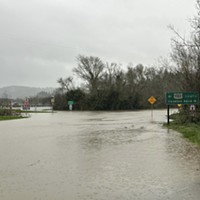
Flood watches are also in effect for Southern Humboldt and Mendocino County starting late tonight and continuing through Thursday afternoon and for the Eel River at Fernbridge. Read more here.
For the latest weather information about specific locations, visit www.weather.gov/eureka.
PREVIOUS:
Another round of severe weather is headed our way for the next few days.
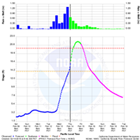
The heaviest rain is forecast for tonight into Wednesday with moderate levels continuing into Thursday, which is expected to cause “rapid rises” on area rivers with some expected to reach monitor or flood stage, according to the Eureka office of the National Weather Service.
“Periods of moderate to heavy rainfall may also cause small streams and low-lying urban areas to flood,” the NWS hydrologic outlook states. “The heaviest rain is likely to fall across primarily Mendocino and southern Humboldt counties, and the melting of recent low elevation snow may also contribute to river rises.”
Snow is also in the forecast but is not expected to bring the coastal dusting that set Humboldt a flutter over the weekend, instead staying at or above 2,500 feet. (See photo of the big snow here).
The NWS hydrologic outlook:

The Eureka office of the National Weather Service has issued a wind advisory for the Humboldt and Mendocino coasts from 8 p.m. Tuesday to 3 p.m. Wednesday as another storm system rolls through the region bringing "heavy rain, gusty winds, and mountain snow."
Flood watches are also in effect for Southern Humboldt and Mendocino County starting late tonight and continuing through Thursday afternoon and for the Eel River at Fernbridge. Read more here.
For the latest weather information about specific locations, visit www.weather.gov/eureka.
PREVIOUS:
Another round of severe weather is headed our way for the next few days.
The heaviest rain is forecast for tonight into Wednesday with moderate levels continuing into Thursday, which is expected to cause “rapid rises” on area rivers with some expected to reach monitor or flood stage, according to the Eureka office of the National Weather Service.
“Periods of moderate to heavy rainfall may also cause small streams and low-lying urban areas to flood,” the NWS hydrologic outlook states. “The heaviest rain is likely to fall across primarily Mendocino and southern Humboldt counties, and the melting of recent low elevation snow may also contribute to river rises.”
Snow is also in the forecast but is not expected to bring the coastal dusting that set Humboldt a flutter over the weekend, instead staying at or above 2,500 feet. (See photo of the big snow here).
Read the NWS weather statement below:Rain, and in some areas snow, is expanding over northwestern California. Precipitation will become heavier tonight, followed by a brief period of lighter precipitation on Wednesday before heavy rain returns Wednesday night into early Thursday. pic.twitter.com/8852PvFca6
— NWS Eureka (@NWSEureka) February 12, 2019
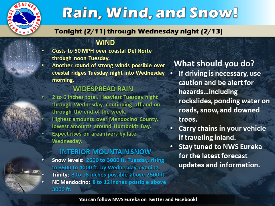
A series of storm systems will bring a wide range of active weather to the region through Wednesday and beyond. This will include widespread moderate to heavy rain, gusty winds, and mountain snow. A Wind Advisory is in effect for coastal portions of Del Norte County through noon Tuesday. Winter Storm Watches are in effect for Trinity County above 2,500 feet and the northeast Mendocino interior above 3,000 feet from Tuesday afternoon through Wednesday afternoon. Please use caution if planning to travel over the next few days, and make sure to monitor road conditions. This forecast is broad and includes a large and diverse area covering all of Northwest California, and conditions will vary widely depending on your specific location.
The NWS hydrologic outlook:
Periods of moderate to heavy rain are expected from late this evening through Thursday afternoon. Rapid rises on area rivers are anticipated, with some main stem rivers expected to reach monitor and flood stage late on Wednesday through early Thursday.
Periods of moderate to heavy rainfall may also cause small streams and low-lying urban areas to flood. The heaviest rain is likely to fall across primarily Mendocino and southern Humboldt counties, and the melting of recent low elevation snow may also contribute to river rises.
Related Stories
Speaking of...
-
UPDATE: Local Emergency Declared Due to Storm Damage
Jan 15, 2024 -
Is Spring About to be Sprung? Warmer Temps May Be Around the Corner
Apr 4, 2023 -
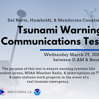
Tsunami Warning Test Day Tomorrow
Mar 28, 2023 - More »
Readers also liked…
About The Author
Kimberly Wear
Bio:
Kimberly Wear is the assistant editor of the North Coast Journal.
Kimberly Wear is the assistant editor of the North Coast Journal.
more from the author
-
Dust to Dust
The green burial movement looks to set down roots in Humboldt County
- Apr 11, 2024
-
Our Last Best Chance
- Apr 11, 2024
-
Judge Rules Arcata Can't Put Earth Flag on Top
- Apr 5, 2024
- More »


