|
by KEITH
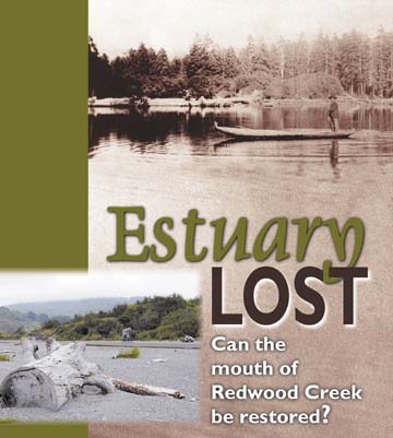
EASTHOUSE THE IMAGE IS GRAINY, AND THE MAN STANDING UP IN THE back end of a long dugout canoe is too far away to see in any detail. The canoe is floating on a still body of water backed by a thick stand of sitka spruce. Like all photographs, this one is essentially a time capsule -- imprinted on its two-dimensional surface is a sort of ghost world, a realm of shadings and light, a faint visual echo of a place. It's clearly a historical shot, so the fact that the man, Ira Dorrence, no longer exists is not surprising. What's unusual is that the place itself, the mouth of Redwood Creek, doesn't really exist anymore either.
Travel forward in time again, to the late 1980s. Another aerial view. [photo below left] The meandering entry into the ocean has been eliminated; the last big bend is gone and Redwood Creek now flows more or less straight to the sea. Immediately to the south, what had been the last arm of the creek is cut off from the main channel; just to the north, the slough is also cut off, blocked from the creek by a mass of sand. Only a narrow band of water stretching out from the main channel actually reaches the ocean.
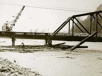
A tangled debateThe environmental degradation caused by the levee -- and the question of what if anything to do about it -- has for years placed the National Park Service and federal and state wildlife agencies at odds with the outfit that built the levee in the first place -- the U.S. Army Corps of Engineers. It has also caused tension with Humboldt County, under contract with the corps to maintain the levee through regular dredging and vegetation removal. The problem took on new urgency in the late 1990s, when three fish species that use the estuary -- coho salmon, chinook salmon and steelhead -- were placed on the federal "threatened" list. It has came to the fore again now that the county has submitted an application to the corps for a new five-year permit to allow it to extract 60,000 cubic yards of gravel annually from the creekbed. Driving the application, in part, is the fact that through the buildup of gravel and sediment in the creek bed, the levee has lost about 20 percent of its channel-carrying capacity. In response to the county's permit application, the Park Service, in a March 29 letter, called on the corps to relax the maintenance requirements the county is laboring under, saying that those requirements "should allow for a more environmentally balanced approach to maintaining the levees." The National Marine Fisheries Service, meantime, in a letter dated March 26, suggested that the corps' requirement that the levee be maintained so that it can handle a 250-year flood event is excessive. "Even though the flood conveyance capacity is not at the design capacity, the flood control project is still providing significant flood protection. The project can currently convey flows near to, or greater than (a) 100-year flood event." Complicating matters further is that the corps itself is divided over the levee system on Redwood Creek. The agency's "regulatory branch" wants to see the levee modified to provide better environmental protection, while its "operations and readiness branch" is concerned exclusively with ensuring that the levee's flood protection abilities don't seriously slip. The fisheries service role in this tangled debate could be particularly important. The agency, along with the California Fish and Game Department and the U.S. Fish and Wildlife Service, is consulting with the corps regarding the levee's impact on the three federally protected fish species. If the service were to determine that the project was placing the continued existence of one or more of the species in danger, it could issue a "jeopardy" opinion that could very well force the corps to relax the county's maintenance responsibilities -- and perhaps lead to a modification of the levee itself so that it would provide a more hospitable environment to the fish. Kelley Reid, of the corps' regulatory branch -- which is concerned primarily with protecting the environment -- said he's hopeful that the consultation process will result in an agreement that "will be beneficial to the resource." Duke Roberts and Eric Behn, both of the corps' San Francisco-based operations and readiness branch, said in a joint interview this week that the process by which any maintenance requirements could be changed on the levee can only be triggered by a formal written request from the county. "We haven't seen that," Behn said. Nor, said Behn, is his branch aware of any proposal to modify the levee itself. Nonetheless, the county is exploring the feasibility of doing precisely that. Armed with a $75,000 grant awarded last fall by the California Coastal Conservancy, the county is studying the possibility of widening the levee -- not near Orick but down near the ocean. A system of "setback levees," as they would be called, could accomplish two things: revive -- at least to an extent -- the estuary; and relieve the county of some of its maintenance responsibilities, which Richard Stein of the county's Public Works Department recently described as "onerous." Don Tuttle, head of Public Works, said in a recent interview that the county's maintenance responsibilities are costing it approximately $20,000 to $30,000 a year. In a 1999 letter, the county estimated it would cost $250,000 to return the levee's flood-carrying capacity to the level it was designed for. Tuttle pointed out that in the event of a breach in the levee during a flood, the county could be held liable. "They'll come knocking at our door first," Tuttle said. Michael Bowen of the coastal conservancy -- like officials with the Park Service and the federal and state wildlife agencies -- does not blame the county for the impasse. "The county's in a Catch-22," Bowen said. "It has an obligation to maintain the flood control system on lower Redwood Creek. However, maintaining it involves dredging gravel and removing vegetation, and (because of increasing environmental concerns) it's getting harder and harder to get the necessary permits to do that work." "The existing situation is largely unworkable," Bowen added. An emotional responseThe levee is 3.4-miles long and begins more than a mile above Orick. It ends approximately 1,000 feet from the shore. The earthen embankments that angle out from either side of the creek are armored with rip-rap, although vegetation pokes out in places and thickets of willow and alder line the water's edge. A few gravel bars created by the creek also support stands of greenery. The area between the levees, the "flood control basin," is approximately 250 feet wide. On a gray day earlier this month, the vertical distance between the surface of the creek and the top of the levee appeared so great that it was hard to imagine the river ever rising that high. That perception changed after a trip to the Palm Cafe, a diner in Orick. There Martha Peals, the owner, laid a series of black-and-white photographs onto a countertop. They were mostly aerial shots -- of Orick and of Redwood Creek, swollen to such an extent that it resembled the Mississippi. This is what the creek looked like in 1964, when days of torrential rain brought disastrous flooding to virtually the entire North Coast. Orick was hit particularly hard, as Redwood Creek -- which drains a mammoth, 280-square-mile watershed -- washed directly into the town. It was that disaster that, four years later, led the corps to build the levee that so drastically changed the lower part of the river. As big as the 1964 flood was, it was merely a 25-year flood event and would be easily handled by the levee that exists today. Even with its flood-carrying capacity reduced, the levee can transport 67,000 cubic feet of water per second; at the height of the 1964 flood, Redwood Creek was flowing at a rate just over 50,000 cubic feet per second. "The levee was an emotional response to a devastating flood," Terry Roeloffs stated flatly.
A simplified systemA fisheries biologist and a longtime professor at Humboldt State University, Roeloffs described the levee as "a classic Corps of Engineers flood control system" -- meaning that it is less than friendly to the environment. It has "simplified" the estuary by "preventing any lateral complexity," Roeloffs said. Forcing the creek into an artificial channel that runs straight to the ocean has deprived the north slough and the river's marooned final bend (the south slough) of any significant current. The lack of circulation has meant that when the ocean batters its way in during winter storms, sand gets deposited and stays there -- it doesn't get flushed out. According to Redwood National and State Parks General Management Plan, approximately 50 percent of the lower estuary has filled in with sand since the levee was constructed 34 years ago. Stagnant water has also translated into warm, dirty water; due to a decrease in oxygen and increased temperatures, the north slough channel -- once abundant with fish -- can no longer support juvenile salmon before they head out to sea. A gated culvert installed in the south levee in 1988 has improved water circulation in the south slough, but has done nothing to prevent the build-up of sand. Overall, Park Service scientists estimate that suitable habitat for fish in the estuary has been reduced by as much as 75 percent. Making the degradation more significant is the fact that estuaries -- along with coral reefs and tropical forests -- are the richest ecosystems in the world in terms of plant production; and where you get lots of plants, you get lots of critters. "Estuaries provide more food per unit volume for fish than anywhere else" in a watershed, Roeloffs said. "It's where fish spend days to weeks to months extending their growing before they go out to the ocean," he added. It's a crucial time, Roeloffs explained, because the larger a fish grows while still in the estuary, the better its chances of survival out in the ocean, where predators are abundant. But there are predators in estuaries, too, and that's why the bigger an estuary is, and the more complex it is in terms of vegetation and woody debris, the better for the fish. "There just aren't that many refuge sites," Roeloffs said, meaning places to hide from predators. "The fish aren't free to meander. Instead of having an edge that's mudflats and salt marshes, you have a rock levee system dominated by willow and alder. Normally the fish would fan out and collect all the nutrients from the plants in the water. Now all they can do is push up the levee."
|

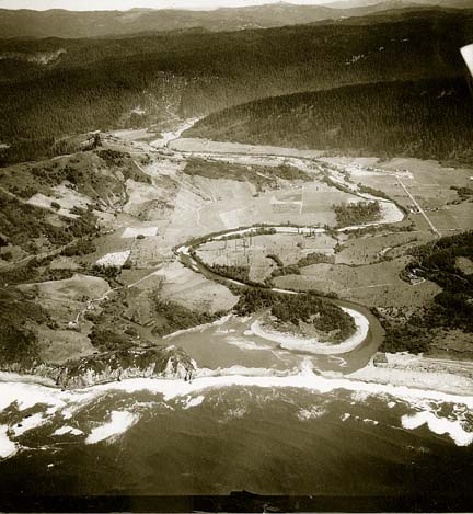 Fast
forward a few decades to 1948. This photograph [at right] is
strikingly different. It includes the location captured in the
earlier image but takes in much more since it was shot from the
air. We see Redwood Creek sweeping down in a giant S-curve to
meet the ocean. It doesn't flow directly in at a perpendicular
angle but instead nestles up to the ocean sideways. Behind a
long sandbar is a lagoon; the sandbar appears to be breached
at one point, but otherwise the lagoon -- or estuary -- is separate
from the sea. Stretching outward from the estuary on the left
side of the photograph are two narrow bodies of water, collectively
called the north slough.
Fast
forward a few decades to 1948. This photograph [at right] is
strikingly different. It includes the location captured in the
earlier image but takes in much more since it was shot from the
air. We see Redwood Creek sweeping down in a giant S-curve to
meet the ocean. It doesn't flow directly in at a perpendicular
angle but instead nestles up to the ocean sideways. Behind a
long sandbar is a lagoon; the sandbar appears to be breached
at one point, but otherwise the lagoon -- or estuary -- is separate
from the sea. Stretching outward from the estuary on the left
side of the photograph are two narrow bodies of water, collectively
called the north slough.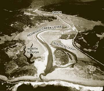 While
its appearance varies seasonally, this last image is essentially
what lower Redwood Creek looks like today. What had been a dramatic
meeting of river and sea is now an ugly and uninteresting joining
of freshwater and saltwater. The mouth of Redwood Creek may be
inside Redwood National Park, but it is not one of the park's
beauty spots. Nor is it what it was in Dorrence's day -- an ecosystem
teeming with fish and other species. Instead, it is simply a
conduit, an engineered waterway that has one overriding purpose:
to prevent flooding, both to the town of Orick two miles up-river
and to the pasture lands that flank the creek on its final passage
to the ocean.
While
its appearance varies seasonally, this last image is essentially
what lower Redwood Creek looks like today. What had been a dramatic
meeting of river and sea is now an ugly and uninteresting joining
of freshwater and saltwater. The mouth of Redwood Creek may be
inside Redwood National Park, but it is not one of the park's
beauty spots. Nor is it what it was in Dorrence's day -- an ecosystem
teeming with fish and other species. Instead, it is simply a
conduit, an engineered waterway that has one overriding purpose:
to prevent flooding, both to the town of Orick two miles up-river
and to the pasture lands that flank the creek on its final passage
to the ocean.
 Buried
ground
Buried
ground Historical photo of estuary fisherman,
from S. Barlow
Historical photo of estuary fisherman,
from S. Barlow