Building a Better Corridor
After tragic accidents and years of delays, the road by the bay needs an upgrade. But what kind?
By Ryan Burns [email protected] @RyanBurnsy[
{
"name": "Top Stories Video Pair",
"insertPoint": "7",
"component": "17087298",
"parentWrapperClass": "fdn-ads-inline-content-block",
"requiredCountToDisplay": "1"
}
]
Newcomers to Humboldt County, especially those arriving from more urban areas, are often amused when locals complain that driving from Arcata to Eureka, or vice-versa, is just "too far." And they have a point. That four-lane stretch of U.S. Route 101 is barely six miles long. Seems longer, right? Maybe that's due, at least in part, to the road's history of tragedies and the signposts that remind us of them. The big signs with flashing lights, the reduced speed limit, the daytime headlight requirement and those radar readouts clocking your speed — it's ominous. One visitor said it felt like she was entering Area 51.
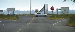
But those flashing, blinking gizmos speak of dangers embedded in the design of the roadway. Scattered along the corridor at irregular intervals are six T-intersections where two-way streets meet the expressway. Every hour of every day, drivers face a challenging and potentially deadly game of Frogger. They're forced to judge the speed of oncoming cars and wait for a gap big enough to shoot across two lanes of traffic. Periodically someone misjudges, often with gruesome results. For cyclists, it's even scarier. This is the "safety corridor," an 11-year-old, 50 mph twilight zone that always was intended to be a temporary fix. Safety zones just don't work long term, says the California Department of Transportation (Caltrans), because people start ignoring them.
Before May 2002, when the safety corridor was created, the prevailing speed on this stretch was nearly 70 miles per hour, despite a speed limit of 60. Also, there were seven intersections, not six. In the five years before the safety measures were installed, collisions at four of the seven intersections happened more frequently than the state average at similar intersections, according to Caltrans reports. Two of the junctures — at Mid-City Motor World and Indianola Boulevard — had more than double the average rate of serious collisions (those resulting in serious injury or death), Caltrans found.
"We even had people renting billboards identifying it as 'Blood Alley,'" said Ralph Martinelli, chief traffic safety officer for Caltrans District 1, which includes Humboldt, Del Norte, Mendocino and Lake counties.
Public outrage over the unsafe conditions reached a fever pitch after a brutal T-bone collision on Jan. 23, 2002. A car had turned left from southbound 101 toward Indianola Boulevard and was crossing northbound 101 when it was plowed into. Four people, including a mom, her son and her father, were killed.
The safety corridor was born. When Caltrans looked back in 2007, comparing the five years before and after the safety corridor's installation, it found that conditions had improved a bit. Though collision rates remained high (and in fact went up) at Mid-City and Indianola, the rate of serious accidents went down at all six intersections. And while there have been fatalities on that stretch in the last decade (including a CR student who fell asleep at the wheel, a cyclist who suffered a heart attack and a driver who inexplicably entered the freeway going the wrong direction), none of the deaths were related to the design of the dangerous intersections.
Regardless, the measures weren't meant to stay. According to a Caltrans study of 29 safety corridors around the state, their effectiveness starts to wear off after a while. People start going faster, enhanced enforcement money runs out and accident rates creep back up. Indeed, both total collision rates and serious collision rates remain well above average on 101 between Arcata and Eureka. "The severity has gone down but the number is climbing back up," said Martinelli, "and we're concerned that at some point it's going to break down completely."
Caltrans has been chipping away at a more permanent solution for more than a dozen years. And as the region's transportation planning agency, the Humboldt County Association of Governments (HCAOG) also plays a major role: It holds decision-making authority for 75 percent of the funds spent locally on state highway projects. Those two agencies, in conjunction with the Federal Highway Administration, have put forth a $46 million design they say will vastly improve safety on the corridor.
However, another state agency, the California Coastal Commission, stands in the way. Charged with protecting the environment along the state's coastline, the commission must sign off on development projects in the coastal zone. Next Thursday, Sept. 12, the Coastal Commission will gather at Eureka's Wharfinger building to decide, among other things, whether Caltrans' proposed design is consistent with federal Coastal Zone guidelines. And commission staffers — in a 45-page report to commissioners — argue that it's not.
In the grand scheme of this project, the consistency determination is just one of many hurdles on the way to a safer 101 corridor. Quite a few other hurdles have been cleared, and some big ones still remain. But this one, which takes a big-picture look at the concept, objectives and design, could either clear a straight path to the finish line or stop the proposed design in its tracks, forcing state and local governments to backtrack and head in a different direction.
The safety corridor's fate has become entangled not just with safety and convenience for drivers but also with wetland protections, the railroad, our rising seas and — at long last — plans for a walking and cycling trail between Arcata and Eureka, which are gaining momentum after years of frustrations.
What might the 101 corridor look like in 2020, the target completion date? Imagine closed medians at four of the six intersections between Arcata and Eureka: those at Mid-City, California Redwood Co., the Bracut lumberyard and the Bayside cutoff. At Airport Road, just north of Eureka, imagine a "half signal" on the east side of Route 101. This light would periodically stop traffic leaving Eureka to allow southbound left turns from Airport Road. (Good news for people renting U-Hauls or buying horse feed on Jacobs Avenue.)
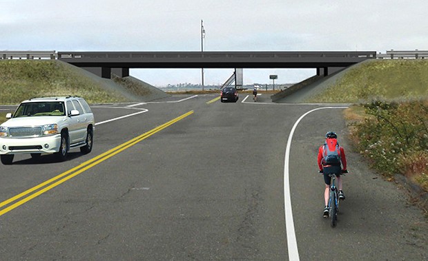
All those changes are part of Caltrans' proposed design, and Coastal Commission staffers have no major argument with them. (Quibbles, yes.) What they do have a significant beef with is Caltrans' plans for the Indianola intersection. There, Caltrans wants to construct an interchange, raising the freeway by 25 feet and building on- and off-ramps to allow cross traffic to pass underneath. This design, says Caltrans, would provide smooth transitions for cars, no matter which direction they're headed.
But Coastal Commission staff doesn't like it. This split-level interchange, the staff report says, is overkill. Traffic signals at Indianola would cause less environmental damage. Furthermore, the report argues, the over/underpass would help traffic flow more easily and so would allow more drivers to use the expressway — a capacity increase which is not allowed on this project. And the whole thing would harm the view and "visual character" of the area.
Other commission objections: It says the interchange could raise speeds on 101, spark commercial development along Indianola and limit future planning options for sea-level rise. Plus, the plan doesn't include any provisions for a separated bicycle and pedestrian path.
Caltrans has responded to these objections, not by changing any of its plans but by disputing commission staff's conclusions on each and every point.
Let's start with the trail. Two years ago, Arcata was one of just two cities (with Fortuna) that voted against funding the project, and the reason was its lack of plans for a bike and pedestrian trail. But Susan Ornelas, an Arcata councilmember and the city's representative on the HCAOG board, feels it's time to reconsider.
"I have come to appreciate Caltrans' 101 corridor update plan," she said in a recent interview. "I have personally decided it is the most graceful and well-designed [alternative] for the automobile. ... But it doesn't make sense without the trail."
After working behind the scenes with representatives of the Coastal Commission, the North Coast Railroad Authority, Caltrans and HCAOG, Ornelas came away convinced that a rail-with-trail project — meaning a trail built alongside the NCRA's eroding rail bed — could be tied to the 101 corridor project. (Disclosure: Journal Publisher Judy Hodgson co-founded the Bay [T]rail Advocates, a group that has been lobbying like mad for this trail.) Ornelas and HCAOG Executive Director Marcella Clem have been arguing that this trail project could be listed as a condition of approval for the 101 corridor project. In other words, if the trail didn't get funded then the corridor project couldn't go forward.
"We do not want one built without the other," Clem said at an Aug. 15 HCAOG meeting.
Trail advocates have reason for optimism lately. Thanks in large part to efforts from the Bay [T]rail Advocates, the NCRA last year agreed to support trail development along its corridor between Arcata and Eureka. And Arcata is moving forward with plans to build the first section of that trail, from the city out to Bracut. Its application for a $2.7 million grant from the federal Transportation Investment Generating Economic Recovery (TIGER) program is pending and appears to be a strong contender. Meanwhile, the county and HCAOG have hired the GHD engineering company to analyze a route for the other half — from Bracut to Eureka — and expects to start applying for funds before the year's out.
But Coastal Commission staff remains skeptical. Although the commission urges applicants to build new sections of the Coastal Trail whenever possible, it considers the current bay trail plans "highly speculative at this point." It argues that Caltrans' corridor remodel would "adversely affect bicycle use" by closing off medians (thus requiring some cyclists to ride out of their way) and by likely increasing the speed limit. It's calling on Caltrans to include in its plans an interim bicycle lane, separated from traffic by a guardrail or a concrete barrier.
Caltrans and HCAOG say that's a terrible idea. For one thing, they dispute the claim that their plans would make things worse for cyclists, and furthermore, they argue, plans for the bay trail are far from speculative. In a rebuttal to the commission's staff report, Caltrans said that building an interim bicycle lane would add at least $12 million to the project, would consume 7.6 acres of wetlands, and "would severely undermine the Bay Trail's future, as HCAOG has stated that it could not support both."
At its Aug. 21 meeting, following advocacy from Ornelas and Clem, the Arcata City Council seemed to change its position on Caltrans' project. In a 4-1 vote, with Councilmember/Mayor Shane Brinton dissenting, the council directed its staff to draft a letter of support for the project, which it plans to finalize at this week's meeting and submit to the Coastal Commission. The hope is that a broad show of community support for the bay trail will convince commissioners that it's not speculative.
But commission staff members aren't the only ones dubious of Caltrans' commitment to a trail. Local environmental groups including Humboldt Baykeeper and the Northcoast Environmental Center say that without a documented promise to fund a trail, Caltrans' proposal should be denied. Jessica Hall, Baykeeper's executive director, said that HCAOG and Caltrans "are describing [the bay trail] as if it's now part of the project, but I don't see how you can say that it is until you've put something on paper."
She's aware that denial of Caltrans' proposal could complicate efforts on the bay trail. "That's the thing I find really unfortunate about the situation," she said. "We don't want to kill a trail proposal that might have legs." But given Coastal Commission staff's other objections and the lack of a firm trail commitment from Caltrans, Hall said Baykeeper can't support the project.
NEC Executive Director Dan Ehresman agrees and says that Caltrans has a history of ignoring its own agency directive, "Complete Streets," which calls for "multimodal" projects that make room for bicyclists and pedestrians.
"A clear priority," Ehresman said, "is to see [the corridor project] clearly and unequivocally linked with the bay trail."
Clem, HCAOG's director, had expected to see a trail linked in writing to the safety corridor fix last week. Instead, when Caltrans, HCAOG and the Federal Highway Administration submitted their final response to the coastal commission on Aug. 28, they made no mention of such a condition. Defiantly (albeit accurately), the response said, "Absent from the legislative regime is any obligation requiring the Applicants to fund or build the trail."
Reached by phone on Monday, Clem expressed frustration that Caltrans wouldn't commit to a trail as had been discussed, especially since Coastal Commission staff seemed open to the bay trail. In its final report to the commission, staff suggested that the bay trail would satisfy the Coastal Act's public access and recreation policies, but only if Caltrans would make a firm commitment to make sure it's funded before the full 101 corridor project.
Besides the trail, the other main points of contention all swirl around the Indianola intersection. Caltrans and HCAOG say a split-level interchange would work best, while Coastal Commission staff says signals would be preferable and environmental leaders say other options should be more fully vetted.
Among its objections to an interchange, the commission staff report says the overpass would significantly alter the natural landscape by requiring 240,000 cubic yards of fill to build steep, 25-foot slopes which would block the view of the bay from Indianola. It also objects to Caltrans' wetland mitigation plans and says the interchange could limit options when it comes to planning for sea-level rise. (Caltrans is set to embark on a sea-level rise study soon; some critics say the corridor plan should wait until the study's complete.)
Humboldt Baykeeper and the Northcoast Environmental Center argue that Caltrans failed to fully consider other viable alternatives. Baykeeper even went so far as to commission its own traffic study from Nelson\Nygaard Consulting Associates. That firm's report, issued last month, urged Caltrans to go back and consider alternatives, particularly roundabouts at Indianola, Airport Road and the Bayside cutoff.
Caltrans and its co-applicants practically sneered in response. Their Aug. 29 missive to the Coastal Commission says Caltrans engineers found that "the signalized alternative would fail spectacularly." These engineers predicted that the average queue at Indianola during rush-hour on northbound 101 would be 104 cars, or about half a mile long. The maximum queue would be 120 cars or more, especially since closed medians elsewhere would divert more drivers to that intersection. This would lead many to avoid the corridor altogether by taking Old Arcata road or State Route 255 through Manila — prospects that frighten communities along both routes.
As for altering the natural landscape and affecting the bay view, the overpass advocates scoffed: "[T]he landscape of the Indianola intersection is anything but natural." If not for "a century of diking and dredging," they pointed out, the whole area would still be underwater. And besides, they said, "The non-native trees, billboards, the abandoned rail line [and] the permanently shuttered drive-in theater ... are also unlikely to be regarded as highly scenic."
They mocked the Nelson\Nygaard study commissioned by Baykeeper, calling it "vague and unsubstantiated," as well as "quite rudimentary and deeply flawed." And they insisted that signalized intersections simply don't work well on roads where drivers go faster than 45 miles per hour.
Ornelas and Clem, with HCAOG, have also been working to find ammunition against the traffic signals proposal. They've been looking at the history of another stretch of U.S. Route 101 — the part just north of the corridor. From the mid-1950s through the early 1970s, 101 traveled right through Arcata, with traffic signals at Seventh and 17th streets. Ornelas and Clem have been scouring microfiche looking for traffic accidents related to those signals.
As Clem reported to the Arcata City Council last month, they found stories about a 27-car pileup with two fatalities that occurred in the thick fog of Jan. 16, 1959. Councilmember Alex Stillman said she remembers when that stretch of 101 had signals. They called it by a familiar name: Blood Alley. HCAOG and Caltrans argue that putting signals at Indianola would only replace T-bone accidents with rear-enders.
"Bear in mind," countered Hall of Humboldt Baykeeper, rear-end accidents "tend to not be fatal."
Caltrans officials have criticized the Coastal Commission for suggesting design alternatives when it's not their job to design roads, but Mark Delaplaine, the commission's federal consistency manager, said it's appropriate. "We're there to ask questions, and we have many, many times disagreed with Caltrans over the best way to build a highway," he said. "Sometimes they've prevailed and sometimes we prevailed."
Looming over all this planning, not to mention just about every coastal community across the world, is the specter of rising seas. And there's evidence to suggest that the Humboldt Bay region could face some of the most serious consequences. Environmental scientist Aldaron Laird recently spent months in a kayak inventorying and mapping all 105 miles of Humboldt Bay's shoreline ("Aldaron's Walkabout," Jan. 5, 2012) as a preliminary step toward planning for sea-level rise.
According to Laird, Humboldt Bay and the surrounding land is subsiding at a rate of roughly 11 inches per century. Combine that with rising seas (a recent study by the National Research Council predicted at least six inches of rise by 2030, three feet by 2100) and it gives Humboldt Bay the highest rate of relative sea-level rise anywhere in California, if not along the entire West Coast, Laird said.
Making matters worse is the condition of the dikes around the bay. As the project applicants alluded to in their quip about Indianola being unnatural, more than 30 percent of Humboldt Bay's historic tidelands were diked off between 1890 and 1910. With no agency in charge of upkeep, those dikes have not been maintained. "They're essentially vertical dirt faces that are just falling off into the sloughs or the bay," Laird said.
Even if the dikes hold up, he added, it would only take two feet of increase in tide elevations to cause the entire dike system to fail. That level of rise could conceivably happen quite soon if a king tide coincides with storm surges, say, from an El Niño weather pattern. "There are thousands of acres of land at risk now," Laird said.
Caltrans is currently partnering with HCAOG to explore ways to protect "critically vulnerable assets" as the climate changes.
But since planning to reconfigure the safety corridor began long ago, (and in fact the road was supposed to be done by now), its plans aren't subject to this climate change strategy.
The Coastal Commission staff says that signals at Indianola "would be less likely to conflict with (and easier to modify to harmonize with)" whatever Caltrans plans for sea-level rise. Humboldt Baykeeper and the NEC are also arguing for Caltrans to consider sea-level rise.
"This is part of a much, much bigger and difficult question about the future of this bay," said Hall. "It is sticky and going to be uncomfortable, but we have to start having that conversation. That's why [it's worth asking], 'Is this the time to do a $50M project?' Maybe what we should be doing is a more low-cost solution that maintains the goals of safety on the 101 corridor."
Laird predicts that 101 will have to be converted into a causeway, raised above the water level. Asked to address the issue, a spokesman for Caltrans acknowledged via email that the entire length of the safety corridor will need to be raised by up to three feet over the next 100 years. And while he didn't explain how, he added, "The proposed Indianola interchange has been designed to accommodate raising 101 in the future."
Finally, let's look at two more contentious issues related to this project: the potential for cars to drive faster on 101 and the potential for businesses to become more interested in locating along Indianola Boulevard and Old Arcata Road.
Speed is a major concern for cycling enthusiasts, who argue that any safety gains made by closing the medians could well be lost by rising speeds on the 101 corridor. In a press release issued after Caltrans announced its design proposal, NEC director Dan Ehresman said, "In Caltrans' attempt to solve a safety problem for automobiles, they could in fact be making it more dangerous for those who travel by bike."
Caltrans has tried to allay those fears. The applicants' defiant response to the Coastal Commission said, "Caltrans is committed to keeping the speed limit at 50 mph within the corridor, insofar as the vehicle code allows." That sounds reassuring until you learn what the vehicle code actually says.
Martinelli, Caltrans' chief traffic safety officer, explained how it works: "By law, Caltrans — or anyone who sets the speed limit —requires an engineering and traffic survey. The process is very clearly stated in the California vehicle code. It's illegal to create a speed trap."
So when the project is complete, Caltrans will have to hire traffic engineers to go out and clock the speeds of cars on the corridor. It then has to base the speed limit on the prevailing speed — that is, the speed that less than 15 percent of drivers exceed.
This regulatory pressure on speed limits makes cycling advocates even more committed to a bay trail because someday soon, cars may be going even faster through the corridor.
As for potential growth inducement, both Caltrans and the Coastal Commission argue that the other guy's plan would somehow encourage businesses to sprout up around Indianola. The reasoning, on both sides, is that as cars slow down approaching Indianola, the drivers will be more likely to look out at their surroundings. A strategically placed gas station or Wendy's might take advantage of that attention.
To make its case, Coastal Commission staff went digging through old Caltrans reports. It found one from 2002 in which Caltrans listed the corridor project among a number of "capacity-increasing" projects. And commission staff went all the way back to the early 1990s to find a Caltrans response to a traffic study for a proposed Wal-Mart on Indianola. In that response, commission staff says, Caltrans predicted a future need for an interchange much like the one it's proposing now and admitted such a structure "could be growth-inducing."
Caltrans now says that there are constraints limiting growth in that area, including the fact that the land is zoned for agricultural use, there's no sewage system and "the high water table makes it likely to stay that way."
Ironically, Caltrans also points to Wal-Mart's efforts as evidence. "Indeed, Wal-Mart, Sam's Club, and Costco have all expressed interest in developing near the Indianola cutoff intersection over past years, but none has done so due to the barrier imposed by coastal development permits in addition to those factors noted above."
The arguments on both sides are highly theoretical, relying on attempts to mind-read future travelers. But it will be up to the Coastal Commission to decide who makes the more compelling case, not just on this issue but on the entire project.
In the community, there are passionate and reasonable people on both sides. Hank Seemann, the county's deputy director of environmental sciences, has been working hard to coordinate local trail efforts, and he says it's time to move forward. "I think the safety issues really warrant addressing this promptly." He understands that some people have concerns based on Caltrans' history but says that HCAOG, as the regional planning agency, is helping hold the agency to its word.
"I'm just hopeful that at the Coastal Commission meeting there's not a decision that really sends it backward," Seemann said. "There needs to be a way to move it forward."
Ornelas was even more effusive. She said that when she and Clem recently traveled to San Francisco to meet with commission staff she told them, "We need this spiritually. We need to know that we can do this, amongst ourselves. That we can cooperate. That we can manifest this ... ."
She sighed. "I just hope we get there."
But others in the community share commission staff's concerns. They say the project is too expensive, that it could make safety worse, and that it ignores years and years of community input on wetland mitigation and a cycling/pedestrian trail. "In a perfect world there would be some way to support the development of other alternatives that deal with the trail in a way that actually moves us forward," said Hall with Baykeeper. But since the only thing before the Commission is Caltrans' plan, she said, her group has no choice but to urge denial.
If the commission does vote to withhold its federal consistency determination, Caltrans would almost certainly have to go back and revise its plans to incorporate the commission's suggestions. Technically Caltrans could appeal the decision to the Secretary of Commerce, but it has never done so before, and commission staff says the move would be pointless.
One last thing: The Coastal Commission wants to hear from the public on this issue. Again, the meeting is next Thursday at the Wharfinger building. The all-day session begins at 8:30 a.m., and the safety corridor item is late on the agenda. Commission staffer Delaplaine says the agency loves feedback. "Ultimately, it's not a popularity contest and the commission has to do what they think is appropriate under the Coastal Act. But the keystone of our agency's success is public participation."
So all those times you've muttered your opinions about the safety corridor? Here's your chance to tell someone who cares.
Note: This story has been corrected from a previous version to reflect the fact that the Bay [T]rail Advocates and local environmental leaders have not taken a stance on the Indianola interchange.
Speaking of...
-
UPDATE: 101 in Mendo Reopens
Mar 28, 2023 -
Reminder: Fernbridge Hard Closure Begins Friday Night
Mar 16, 2023 -
Sheriff's Office to Snow Goers: 'Please Stay Home'
Mar 6, 2023 - More »
Comments (2)
Showing 1-2 of 2
more from the author
-
Unequal Opportunities
Behind the ACLU's allegations of racial, sexual and disability discrimination in local schools
- Jan 2, 2014
-
Last Days of the Surfing DA
Heading into his final year in office, Paul Gallegos talks politics, family and The Smiths
- Jan 2, 2014
-
Systematically Misled
- Dec 26, 2013
- More »
Latest in News
Readers also liked…
-
Through Mark Larson's Lens
A local photographer's favorite images of 2022 in Humboldt
- Jan 5, 2023
-
'To Celebrate Our Sovereignty'
Yurok Tribe to host gathering honoring 'ultimate river warrior' on the anniversary of the U.S. Supreme Court ruling that changed everything
- Jun 8, 2023
