Tuesday, December 9, 2014
Batten Down the Hatches
Posted By Grant Scott-Goforth @GScottGoforth on Tue, Dec 9, 2014 at 11:28 AM
The North Coast is about to be battered with bad weather — exciting, we know, and California needs water — but that means dangerous conditions for the outdoors-minded among us.
High surf, strong winds and lots of rain are expected to land tonight and continue through late Thursday/early Friday.
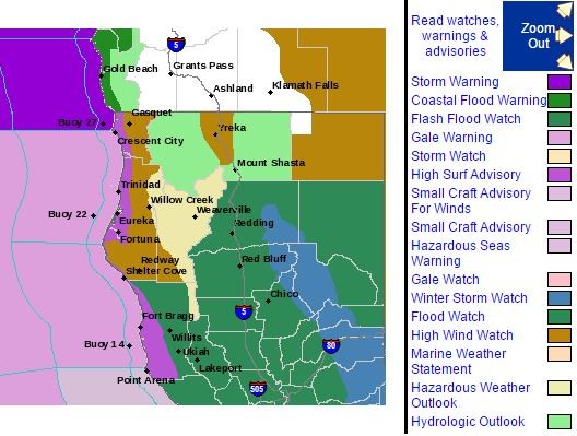
The National Weather Service issued a high surf advisory — predicting 24-foot breaking waves through Wednesday night. That means it’s super dangerous to be on beaches, oceanside rocks and jetties, folks, so if you must see the waves do it from high above the waters, like the Trinidad bluffs.
“These large waves can be erratic and unpredictable,” the weather service warns. “Use extra caution near the surf zone as these large waves will be capable of sweeping people into the frigid and turbulent ocean waters.”
Rain is expected to bring the Eel River at Fernbridge to flood stage by early Thursday, and low lying areas and creeks and streams could flood. On top of that, high winds — 15 to 30 mph with 45 mph gusts and 60 mph (!) gusts in coastal headlands and ridgetops — will buffet the area, particularly in Trinidad, Crescent City, Kneeland and Fickle Hill.
The Weather Service and Coast Guard are also warning boaters about the conditions. A small craft advisory has been issued for the waters off the North Coast. “Mariners traversing the [Humboldt Bay] bar are urged to exercise extreme caution or stay in port until the threat subsides.”
From the Coasties:
The Coast Guard cautions the public to exercise safe and responsible boating practices and to keep beach safety guidelines in mind as high seas, strong winds and rain are predicted to impact Northern California, starting Tuesday evening and continuing through Thursday.
Waves between 15 and 25 feet, and wind gusts as high as 60 mph are expected which can be dangerous. The most severe weather is forecasted near the Oregon border.
Please check NOAA area weather for the latest updates prior to getting underway: www.wrh.noaa.gov/eka.
The Coast Guard reminds people to avoid going near low-lying beaches and other coastal areas including jetties and rocky areas during heavy weather. Large waves can quickly and unexpectedly sweep a person from these areas.
It is recommended that individuals avoid taking to the water during storm conditions. If it is necessary to get underway, mariners are urged to check all of their safety equipment to ensure it is in good condition and working properly.
The Coast Guard also encourages all vessel owners and operators to check the status of mooring and anchoring arrangements. Vessels that are not properly secured during a storm can break free from moorings, often a result of worn lines, an insufficient numbers of lines, or an improperly sized anchor or anchor chain. It is a good idea to double up vessel mooring lines during strong winds and heavy seas. Vessels that become adrift pose severe hazards to nearby people and vessels and can also pose environmental risks as any fluids or chemicals aboard can spill or leak. The Coast Guard urges vessel owners and operators to take extra precautions in anticipation of the forecasted storm system by addressing mooring safety and securing potential sources of marine pollution.
USCG Storm Center: www.uscg.mil/news/stormcenter.
USCG Safe Boating: www.uscgboating.org.
High surf, strong winds and lots of rain are expected to land tonight and continue through late Thursday/early Friday.
The National Weather Service issued a high surf advisory — predicting 24-foot breaking waves through Wednesday night. That means it’s super dangerous to be on beaches, oceanside rocks and jetties, folks, so if you must see the waves do it from high above the waters, like the Trinidad bluffs.
“These large waves can be erratic and unpredictable,” the weather service warns. “Use extra caution near the surf zone as these large waves will be capable of sweeping people into the frigid and turbulent ocean waters.”
Rain is expected to bring the Eel River at Fernbridge to flood stage by early Thursday, and low lying areas and creeks and streams could flood. On top of that, high winds — 15 to 30 mph with 45 mph gusts and 60 mph (!) gusts in coastal headlands and ridgetops — will buffet the area, particularly in Trinidad, Crescent City, Kneeland and Fickle Hill.
The Weather Service and Coast Guard are also warning boaters about the conditions. A small craft advisory has been issued for the waters off the North Coast. “Mariners traversing the [Humboldt Bay] bar are urged to exercise extreme caution or stay in port until the threat subsides.”
From the Coasties:
The Coast Guard cautions the public to exercise safe and responsible boating practices and to keep beach safety guidelines in mind as high seas, strong winds and rain are predicted to impact Northern California, starting Tuesday evening and continuing through Thursday.
Waves between 15 and 25 feet, and wind gusts as high as 60 mph are expected which can be dangerous. The most severe weather is forecasted near the Oregon border.
Please check NOAA area weather for the latest updates prior to getting underway: www.wrh.noaa.gov/eka.
The Coast Guard reminds people to avoid going near low-lying beaches and other coastal areas including jetties and rocky areas during heavy weather. Large waves can quickly and unexpectedly sweep a person from these areas.
It is recommended that individuals avoid taking to the water during storm conditions. If it is necessary to get underway, mariners are urged to check all of their safety equipment to ensure it is in good condition and working properly.
The Coast Guard also encourages all vessel owners and operators to check the status of mooring and anchoring arrangements. Vessels that are not properly secured during a storm can break free from moorings, often a result of worn lines, an insufficient numbers of lines, or an improperly sized anchor or anchor chain. It is a good idea to double up vessel mooring lines during strong winds and heavy seas. Vessels that become adrift pose severe hazards to nearby people and vessels and can also pose environmental risks as any fluids or chemicals aboard can spill or leak. The Coast Guard urges vessel owners and operators to take extra precautions in anticipation of the forecasted storm system by addressing mooring safety and securing potential sources of marine pollution.
USCG Storm Center: www.uscg.mil/news/stormcenter.
USCG Safe Boating: www.uscgboating.org.
Speaking of...
-

Indigenous Foodways, Wind Farm Opposition and Big Boats
Mar 31, 2024 -
Humboldt Bay Timeline
Oct 12, 2023 -
Photos: Kinetic Day Two (by Sea)
May 29, 2023 - More »
Comments
Showing 1-1 of 1
Readers also liked…
About The Author

Grant Scott-Goforth
Bio:
Grant Scott-Goforth was an assistant editor and staff writer for The Journal from 2013 to 2017.
Grant Scott-Goforth was an assistant editor and staff writer for The Journal from 2013 to 2017.
more from the author
-
Flamin' Hot's Stale Corporate Propaganda
- Jun 15, 2023
-
Hell is Visiting Other People
- Sep 22, 2022
-
The Bear Roars
- Aug 18, 2022
- More »


